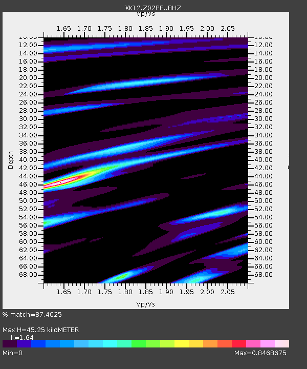
Z02PP Mapepala Health Center, Zambia - Earthquake Result Viewer

Earthquake location: Nicobar Islands, India Region
Earthquake latitude/longitude: 7.8/94.3
Earthquake time(UTC): 2014/03/21 (080) 13:41:07 GMT
Earthquake Depth: 10 km
Earthquake Magnitude: 6.5 MWB, 6.4 MWC, 6.4 MWB, 6.4 MWW
Earthquake Catalog/Contributor: NEIC PDE/NEIC COMCAT
Network: XK Seismic Arrays for African Rift Initation
Station: Z02PP Mapepala Health Center, Zambia
Lat/Lon: 12.70 S/30.14 E
Elevation: 1237 m
Distance: 66.9 deg
Az: 252.71 deg
Baz: 75.828 deg
Ray Param: 0.057283554
Estimated Moho Depth: 45.25 km
Estimated Crust Vp/Vs: 1.64
Assumed Crust Vp: 6.367 km/s
Estimated Crust Vs: 3.882 km/s
Estimated Crust Poisson's Ratio: 0.20
Radial Match: 87.4025 %
Radial Bump: 395
Transverse Match: 71.75441 %
Transverse Bump: 400
SOD ConfigId: 3390531
Insert Time: 2019-04-10 19:16:53.918 +0000
GWidth: 2.5
Max Bumps: 400
Tol: 0.001

Signal To Noise

ChannelStoNSTALTA
XK:Z02PP: :BHZ:20140321T13:51:29.039978Z1.4955212.457946E-71.6435385E-7
XK:Z02PP: :BHN:20140321T13:51:29.039978Z1.3783341.3131935E-79.5273975E-8
XK:Z02PP: :BHE:20140321T13:51:29.039978Z2.5374582.0403355E-78.040865E-8
Arrivals
Ps4.7 SECOND
PpPs18 SECOND
PsPs/PpSs23 SECOND