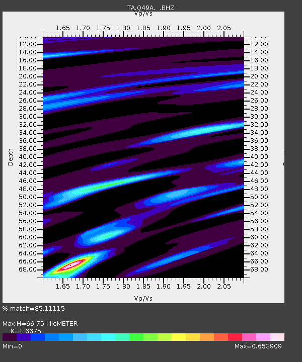
Q49A Aurora, IN, USA - Earthquake Result Viewer

Earthquake location: Queen Charlotte Islands Region
Earthquake latitude/longitude: 51.2/-130.4
Earthquake time(UTC): 2013/09/03 (246) 20:19:06 GMT
Earthquake Depth: 2.7 km
Earthquake Magnitude: 6.1 MWW, 6.0 MWB, 6.1 MWW, 6.1 MWC, 6.2 MI, 6.2 MWC
Earthquake Catalog/Contributor: NEIC PDE/NEIC COMCAT
Network: TA USArray Transportable Network (new EarthScope stations)
Station: Q49A Aurora, IN, USA
Lat/Lon: 39.01 N/84.90 W
Elevation: 264 m
Distance: 33.8 deg
Az: 93.165 deg
Baz: 306.342 deg
Ray Param: 0.078046754
Estimated Moho Depth: 66.75 km
Estimated Crust Vp/Vs: 1.67
Assumed Crust Vp: 6.498 km/s
Estimated Crust Vs: 3.897 km/s
Estimated Crust Poisson's Ratio: 0.22
Radial Match: 85.11115 %
Radial Bump: 288
Transverse Match: 70.3354 %
Transverse Bump: 400
SOD ConfigId: 626651
Insert Time: 2014-04-18 08:44:48.644 +0000
GWidth: 2.5
Max Bumps: 400
Tol: 0.001

Signal To Noise

ChannelStoNSTALTA
TA:Q49A: :BHZ:20130903T20:25:18.97501Z2.47439056.487638E-72.6219135E-7
TA:Q49A: :BHN:20130903T20:25:18.97501Z1.69799532.843807E-71.6748025E-7
TA:Q49A: :BHE:20130903T20:25:18.97501Z2.6255894.040769E-71.5389952E-7
Arrivals
Ps7.5 SECOND
PpPs25 SECOND
PsPs/PpSs33 SECOND