You are here: Home > Network List > TA - USArray Transportable Network (new EarthScope stations) Stations List
> Station Q49A Aurora, IN, USA > Earthquake Result Viewer
Q49A Aurora, IN, USA - Earthquake Result Viewer
| Earthquake location: |
Near Coast Of Northern Chile |
| Earthquake latitude/longitude: |
-19.8/-70.9 |
| Earthquake time(UTC): |
2014/03/22 (081) 12:59:59 GMT |
| Earthquake Depth: |
20 km |
| Earthquake Magnitude: |
6.2 MWW, 6.2 MWB, 6.3 MWC, 6.4 MWC |
| Earthquake Catalog/Contributor: |
NEIC PDE/NEIC COMCAT |
|
| Network: |
TA USArray Transportable Network (new EarthScope stations) |
| Station: |
Q49A Aurora, IN, USA |
| Lat/Lon: |
39.01 N/84.90 W |
| Elevation: |
264 m |
|
| Distance: |
59.9 deg |
| Az: |
347.399 deg |
| Baz: |
164.709 deg |
| Ray Param: |
0.061852332 |
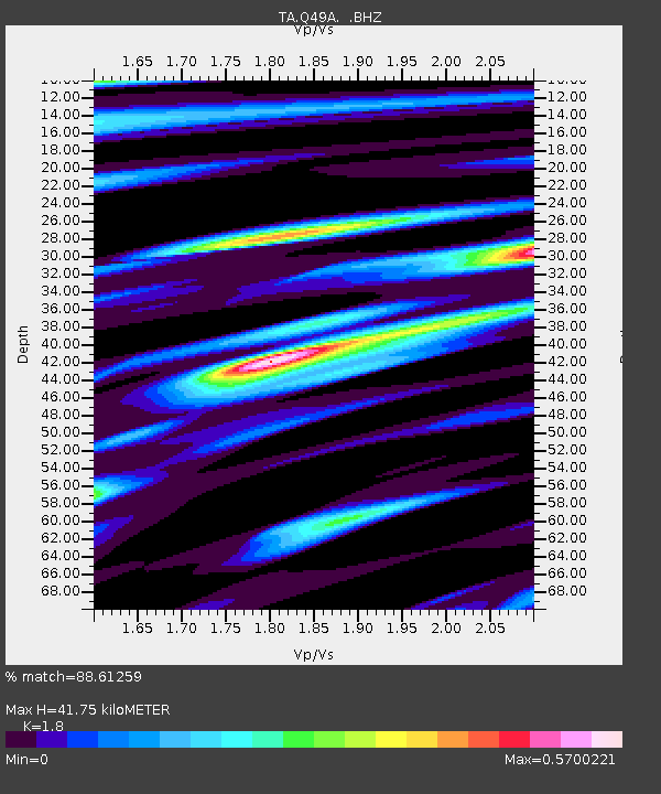
| Estimated Moho Depth: |
41.75 km |
| Estimated Crust Vp/Vs: |
1.80 |
| Assumed Crust Vp: |
6.498 km/s |
| Estimated Crust Vs: |
3.61 km/s |
| Estimated Crust Poisson's Ratio: |
0.28 |
|
| Radial Match: |
88.61259 % |
| Radial Bump: |
376 |
| Transverse Match: |
65.39727 % |
| Transverse Bump: |
400 |
| SOD ConfigId: |
626651 |
| Insert Time: |
2014-04-21 10:42:05.950 +0000 |
| GWidth: |
2.5 |
| Max Bumps: |
400 |
| Tol: |
0.001 |
|

Signal To Noise
| Channel | StoN | STA | LTA |
| TA:Q49A: :BHZ:20140322T13:09:32.650Z | 6.9501295 | 1.0075231E-6 | 1.4496466E-7 |
| TA:Q49A: :BHN:20140322T13:09:32.650Z | 1.7451795 | 2.6284636E-7 | 1.5061279E-7 |
| TA:Q49A: :BHE:20140322T13:09:32.650Z | 0.9644489 | 1.5915192E-7 | 1.650185E-7 |
| Arrivals |
| Ps | 5.4 SECOND |
| PpPs | 17 SECOND |
| PsPs/PpSs | 23 SECOND |


