You are here: Home > Network List > TA - USArray Transportable Network (new EarthScope stations) Stations List
> Station Q49A Aurora, IN, USA > Earthquake Result Viewer
Q49A Aurora, IN, USA - Earthquake Result Viewer
| Earthquake location: |
Near Coast Of Northern Chile |
| Earthquake latitude/longitude: |
-19.8/-70.9 |
| Earthquake time(UTC): |
2014/04/02 (092) 00:03:12 GMT |
| Earthquake Depth: |
10 km |
| Earthquake Magnitude: |
5.8 MB |
| Earthquake Catalog/Contributor: |
NEIC PDE/NEIC COMCAT |
|
| Network: |
TA USArray Transportable Network (new EarthScope stations) |
| Station: |
Q49A Aurora, IN, USA |
| Lat/Lon: |
39.01 N/84.90 W |
| Elevation: |
264 m |
|
| Distance: |
60.0 deg |
| Az: |
347.409 deg |
| Baz: |
164.73 deg |
| Ray Param: |
0.061822288 |
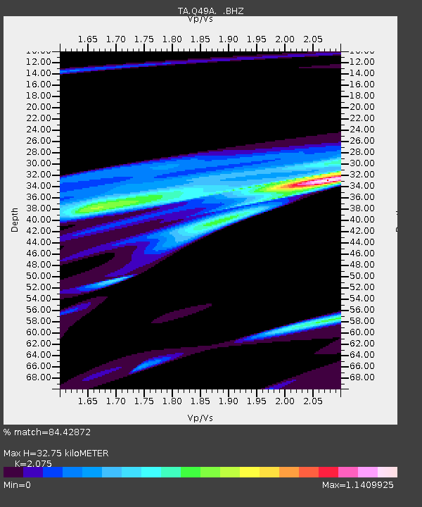
| Estimated Moho Depth: |
32.75 km |
| Estimated Crust Vp/Vs: |
2.08 |
| Assumed Crust Vp: |
6.498 km/s |
| Estimated Crust Vs: |
3.131 km/s |
| Estimated Crust Poisson's Ratio: |
0.35 |
|
| Radial Match: |
84.42872 % |
| Radial Bump: |
386 |
| Transverse Match: |
65.61316 % |
| Transverse Bump: |
346 |
| SOD ConfigId: |
626651 |
| Insert Time: |
2014-04-21 22:19:31.414 +0000 |
| GWidth: |
2.5 |
| Max Bumps: |
400 |
| Tol: |
0.001 |
|

Signal To Noise
| Channel | StoN | STA | LTA |
| TA:Q49A: :BHZ:20140402T00:12:47.55002Z | 1.0480723 | 6.6365574E-5 | 6.332156E-5 |
| TA:Q49A: :BHN:20140402T00:12:47.55002Z | 0.57839465 | 2.8830635E-5 | 4.9845956E-5 |
| TA:Q49A: :BHE:20140402T00:12:47.55002Z | 2.6995206 | 6.296538E-5 | 2.3324654E-5 |
| Arrivals |
| Ps | 5.6 SECOND |
| PpPs | 15 SECOND |
| PsPs/PpSs | 21 SECOND |


