You are here: Home > Network List > US - United States National Seismic Network Stations List
> Station WCI Wyandotte Cave, Indiana, USA > Earthquake Result Viewer
WCI Wyandotte Cave, Indiana, USA - Earthquake Result Viewer
| Earthquake location: |
Near Coast Of Central Chile |
| Earthquake latitude/longitude: |
-38.9/-73.2 |
| Earthquake time(UTC): |
2004/06/15 (167) 11:16:31 GMT |
| Earthquake Depth: |
38 km |
| Earthquake Magnitude: |
5.7 MB, 5.4 MS, 6.1 MW, 5.9 MW |
| Earthquake Catalog/Contributor: |
WHDF/NEIC |
|
| Network: |
US United States National Seismic Network |
| Station: |
WCI Wyandotte Cave, Indiana, USA |
| Lat/Lon: |
38.23 N/86.29 W |
| Elevation: |
500 m |
|
| Distance: |
77.7 deg |
| Az: |
349.44 deg |
| Baz: |
169.532 deg |
| Ray Param: |
0.050117176 |
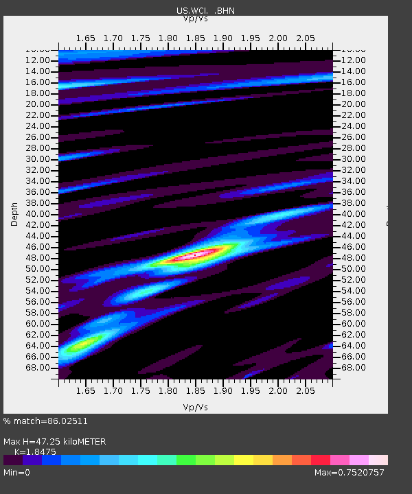
| Estimated Moho Depth: |
47.25 km |
| Estimated Crust Vp/Vs: |
1.85 |
| Assumed Crust Vp: |
6.444 km/s |
| Estimated Crust Vs: |
3.488 km/s |
| Estimated Crust Poisson's Ratio: |
0.29 |
|
| Radial Match: |
86.02511 % |
| Radial Bump: |
400 |
| Transverse Match: |
68.07153 % |
| Transverse Bump: |
400 |
| SOD ConfigId: |
110177 |
| Insert Time: |
2010-03-05 06:34:11.545 +0000 |
| GWidth: |
2.5 |
| Max Bumps: |
400 |
| Tol: |
0.001 |
|

Signal To Noise
| Channel | StoN | STA | LTA |
| US:WCI: :BHN:20040615T11:27:53.038025Z | 1.7178155 | 9.4716846E-8 | 5.5137964E-8 |
| US:WCI: :BHE:20040615T11:27:53.038025Z | 0.6568601 | 4.1569614E-8 | 6.328534E-8 |
| US:WCI: :BHZ:20040615T11:27:53.038025Z | 2.9066186 | 2.2709183E-7 | 7.812922E-8 |
| Arrivals |
| Ps | 6.4 SECOND |
| PpPs | 20 SECOND |
| PsPs/PpSs | 27 SECOND |


