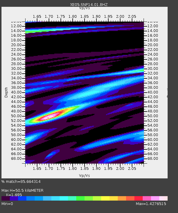
SNP14 SNP14 - Earthquake Result Viewer

Earthquake location: New Britain Region, P.N.G.
Earthquake latitude/longitude: -5.4/151.8
Earthquake time(UTC): 2005/09/29 (272) 15:50:24 GMT
Earthquake Depth: 25 km
Earthquake Magnitude: 5.9 MB, 6.6 MS, 6.7 MW, 6.5 MW
Earthquake Catalog/Contributor: WHDF/NEIC
Network: XE Sierra Nevada EarthScope Project- EarthScope Flex Array
Station: SNP14 SNP14
Lat/Lon: 37.14 N/118.77 W
Elevation: 3056 m
Distance: 92.8 deg
Az: 53.129 deg
Baz: 265.312 deg
Ray Param: 0.041388966
Estimated Moho Depth: 50.5 km
Estimated Crust Vp/Vs: 1.70
Assumed Crust Vp: 6.291 km/s
Estimated Crust Vs: 3.712 km/s
Estimated Crust Poisson's Ratio: 0.23
Radial Match: 85.664314 %
Radial Bump: 400
Transverse Match: 62.894897 %
Transverse Bump: 400
SOD ConfigId: 268666
Insert Time: 2010-03-09 14:44:05.661 +0000
GWidth: 2.5
Max Bumps: 400
Tol: 0.001

Signal To Noise

ChannelStoNSTALTA
XE:SNP14:01:BHZ:20050929T16:03:02.54001Z2.40227133.5671084E-71.4848898E-7
XE:SNP14:01:BHN:20050929T16:03:02.54001Z2.68173311.7962844E-76.6982224E-8
XE:SNP14:01:BHE:20050929T16:03:02.54001Z1.20655622.2704684E-71.8817758E-7
Arrivals
Ps5.7 SECOND
PpPs21 SECOND
PsPs/PpSs27 SECOND