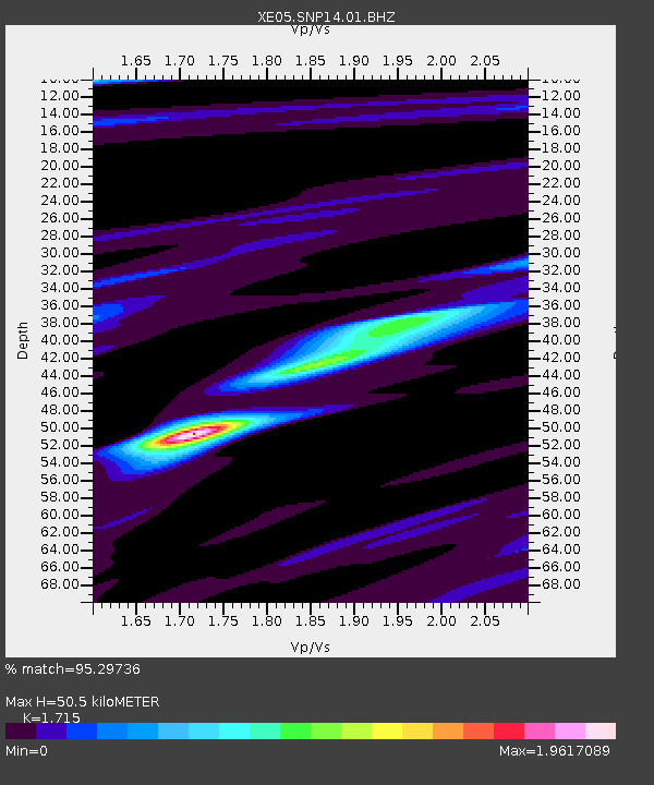
SNP14 SNP14 - Earthquake Result Viewer

Earthquake location: Fiji Islands Region
Earthquake latitude/longitude: -15.3/-178.6
Earthquake time(UTC): 2005/12/13 (347) 03:16:06 GMT
Earthquake Depth: 10 km
Earthquake Magnitude: 6.1 MB, 6.8 MS, 6.7 MW, 6.7 MW
Earthquake Catalog/Contributor: WHDF/NEIC
Network: XE Sierra Nevada EarthScope Project- EarthScope Flex Array
Station: SNP14 SNP14
Lat/Lon: 37.14 N/118.77 W
Elevation: 3056 m
Distance: 76.7 deg
Az: 45.217 deg
Baz: 239.011 deg
Ray Param: 0.05084436
Estimated Moho Depth: 50.5 km
Estimated Crust Vp/Vs: 1.72
Assumed Crust Vp: 6.291 km/s
Estimated Crust Vs: 3.668 km/s
Estimated Crust Poisson's Ratio: 0.24
Radial Match: 95.29736 %
Radial Bump: 284
Transverse Match: 83.71688 %
Transverse Bump: 400
SOD ConfigId: 268666
Insert Time: 2010-03-09 14:44:12.764 +0000
GWidth: 2.5
Max Bumps: 400
Tol: 0.001

Signal To Noise

ChannelStoNSTALTA
XE:SNP14:01:BHZ:20051213T03:27:25.989009Z4.8396279.740047E-72.0125616E-7
XE:SNP14:01:BHN:20051213T03:27:25.989009Z3.49866583.1298788E-78.945921E-8
XE:SNP14:01:BHE:20051213T03:27:25.989009Z3.00804045.541318E-71.8421689E-7
Arrivals
Ps5.9 SECOND
PpPs21 SECOND
PsPs/PpSs27 SECOND