You are here: Home > Network List > XE05 - Sierra Nevada EarthScope Project- EarthScope Flex Array Stations List
> Station SNP14 SNP14 > Earthquake Result Viewer
SNP14 SNP14 - Earthquake Result Viewer
| Earthquake location: |
South Of Fiji Islands |
| Earthquake latitude/longitude: |
-23.6/-180.0 |
| Earthquake time(UTC): |
2006/02/26 (057) 03:08:27 GMT |
| Earthquake Depth: |
535 km |
| Earthquake Magnitude: |
5.9 MB, 6.4 MW, 6.4 MW |
| Earthquake Catalog/Contributor: |
WHDF/NEIC |
|
| Network: |
XE Sierra Nevada EarthScope Project- EarthScope Flex Array |
| Station: |
SNP14 SNP14 |
| Lat/Lon: |
37.14 N/118.77 W |
| Elevation: |
3056 m |
|
| Distance: |
83.5 deg |
| Az: |
44.824 deg |
| Baz: |
234.016 deg |
| Ray Param: |
0.044608474 |
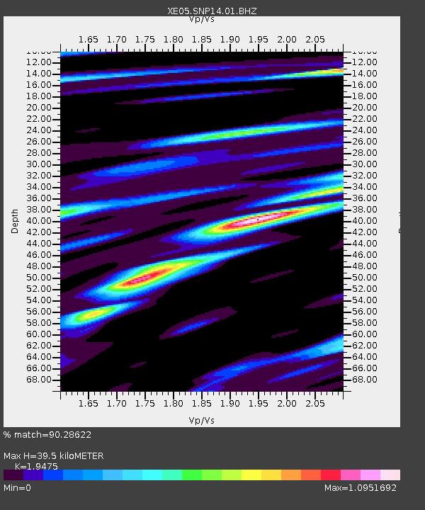
| Estimated Moho Depth: |
39.5 km |
| Estimated Crust Vp/Vs: |
1.95 |
| Assumed Crust Vp: |
6.291 km/s |
| Estimated Crust Vs: |
3.23 km/s |
| Estimated Crust Poisson's Ratio: |
0.32 |
|
| Radial Match: |
90.28622 % |
| Radial Bump: |
400 |
| Transverse Match: |
71.782295 % |
| Transverse Bump: |
400 |
| SOD ConfigId: |
268666 |
| Insert Time: |
2010-03-09 14:44:17.574 +0000 |
| GWidth: |
2.5 |
| Max Bumps: |
400 |
| Tol: |
0.001 |
|

Signal To Noise
| Channel | StoN | STA | LTA |
| XE:SNP14:01:BHZ:20060226T03:19:27.989016Z | 14.359535 | 2.915113E-6 | 2.0300888E-7 |
| XE:SNP14:01:BHN:20060226T03:19:27.989016Z | 5.5287933 | 7.440409E-7 | 1.3457564E-7 |
| XE:SNP14:01:BHE:20060226T03:19:27.989016Z | 7.7875853 | 9.798867E-7 | 1.2582679E-7 |
| Arrivals |
| Ps | 6.1 SECOND |
| PpPs | 18 SECOND |
| PsPs/PpSs | 24 SECOND |


