You are here: Home > Network List > XE05 - Sierra Nevada EarthScope Project- EarthScope Flex Array Stations List
> Station SNP14 SNP14 > Earthquake Result Viewer
SNP14 SNP14 - Earthquake Result Viewer
| Earthquake location: |
Kermadec Islands Region |
| Earthquake latitude/longitude: |
-31.8/-179.3 |
| Earthquake time(UTC): |
2006/05/16 (136) 10:39:23 GMT |
| Earthquake Depth: |
152 km |
| Earthquake Magnitude: |
6.8 MB, 7.4 MW, 7.4 MW |
| Earthquake Catalog/Contributor: |
WHDF/NEIC |
|
| Network: |
XE Sierra Nevada EarthScope Project- EarthScope Flex Array |
| Station: |
SNP14 SNP14 |
| Lat/Lon: |
37.14 N/118.77 W |
| Elevation: |
3056 m |
|
| Distance: |
88.9 deg |
| Az: |
44.1 deg |
| Baz: |
227.874 deg |
| Ray Param: |
0.0419336 |
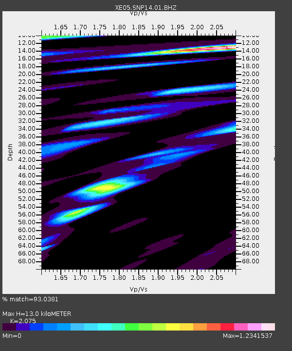
| Estimated Moho Depth: |
13.0 km |
| Estimated Crust Vp/Vs: |
2.08 |
| Assumed Crust Vp: |
6.291 km/s |
| Estimated Crust Vs: |
3.032 km/s |
| Estimated Crust Poisson's Ratio: |
0.35 |
|
| Radial Match: |
93.0381 % |
| Radial Bump: |
400 |
| Transverse Match: |
79.09337 % |
| Transverse Bump: |
400 |
| SOD ConfigId: |
268666 |
| Insert Time: |
2010-03-09 14:44:27.526 +0000 |
| GWidth: |
2.5 |
| Max Bumps: |
400 |
| Tol: |
0.001 |
|

Signal To Noise
| Channel | StoN | STA | LTA |
| XE:SNP14:01:BHZ:20060516T10:51:29.188999Z | 5.5678463 | 6.527138E-7 | 1.1722914E-7 |
| XE:SNP14:01:BHN:20060516T10:51:29.188999Z | 1.2100091 | 2.628322E-7 | 2.1721507E-7 |
| XE:SNP14:01:BHE:20060516T10:51:29.188999Z | 0.4630071 | 2.2976194E-7 | 4.962385E-7 |
| Arrivals |
| Ps | 2.3 SECOND |
| PpPs | 6.2 SECOND |
| PsPs/PpSs | 8.5 SECOND |


