You are here: Home > Network List > XE05 - Sierra Nevada EarthScope Project- EarthScope Flex Array Stations List
> Station SNP14 SNP14 > Earthquake Result Viewer
SNP14 SNP14 - Earthquake Result Viewer
| Earthquake location: |
Fiji Islands Region |
| Earthquake latitude/longitude: |
-21.2/-176.3 |
| Earthquake time(UTC): |
2006/08/15 (227) 23:53:47 GMT |
| Earthquake Depth: |
158 km |
| Earthquake Magnitude: |
5.9 MB, 6.1 MW, 6.1 MW |
| Earthquake Catalog/Contributor: |
WHDF/NEIC |
|
| Network: |
XE Sierra Nevada EarthScope Project- EarthScope Flex Array |
| Station: |
SNP14 SNP14 |
| Lat/Lon: |
37.14 N/118.77 W |
| Elevation: |
3056 m |
|
| Distance: |
79.3 deg |
| Az: |
43.285 deg |
| Baz: |
233.196 deg |
| Ray Param: |
0.048640486 |
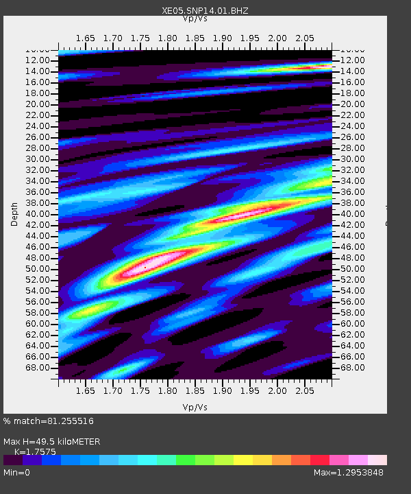
| Estimated Moho Depth: |
49.5 km |
| Estimated Crust Vp/Vs: |
1.76 |
| Assumed Crust Vp: |
6.291 km/s |
| Estimated Crust Vs: |
3.58 km/s |
| Estimated Crust Poisson's Ratio: |
0.26 |
|
| Radial Match: |
81.255516 % |
| Radial Bump: |
400 |
| Transverse Match: |
77.48555 % |
| Transverse Bump: |
400 |
| SOD ConfigId: |
268666 |
| Insert Time: |
2010-03-09 14:44:36.590 +0000 |
| GWidth: |
2.5 |
| Max Bumps: |
400 |
| Tol: |
0.001 |
|

Signal To Noise
| Channel | StoN | STA | LTA |
| XE:SNP14:01:BHZ:20060816T00:05:04.414011Z | 14.85199 | 1.2264057E-6 | 8.257518E-8 |
| XE:SNP14:01:BHN:20060816T00:05:04.414011Z | 3.896105 | 3.2295372E-7 | 8.289143E-8 |
| XE:SNP14:01:BHE:20060816T00:05:04.414011Z | 3.7409816 | 3.891151E-7 | 1.0401417E-7 |
| Arrivals |
| Ps | 6.1 SECOND |
| PpPs | 21 SECOND |
| PsPs/PpSs | 27 SECOND |


