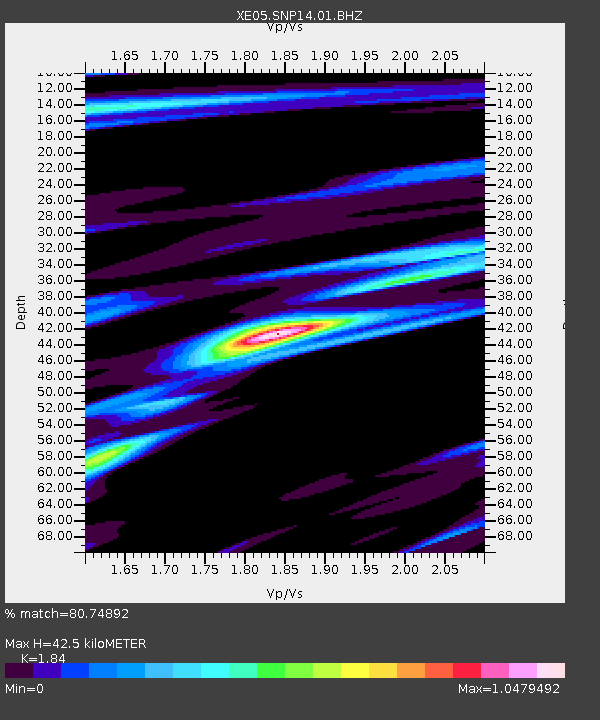
SNP14 SNP14 - Earthquake Result Viewer

Earthquake location: Solomon Islands
Earthquake latitude/longitude: -7.8/156.5
Earthquake time(UTC): 2007/04/04 (094) 06:34:38 GMT
Earthquake Depth: 31 km
Earthquake Magnitude: 6.0 MB, 6.3 MS, 6.4 MW, 6.2 MW
Earthquake Catalog/Contributor: WHDF/NEIC
Network: XE Sierra Nevada EarthScope Project- EarthScope Flex Array
Station: SNP14 SNP14
Lat/Lon: 37.14 N/118.77 W
Elevation: 3056 m
Distance: 90.5 deg
Az: 52.727 deg
Baz: 260.67 deg
Ray Param: 0.04166793
Estimated Moho Depth: 42.5 km
Estimated Crust Vp/Vs: 1.84
Assumed Crust Vp: 6.291 km/s
Estimated Crust Vs: 3.419 km/s
Estimated Crust Poisson's Ratio: 0.29
Radial Match: 80.74892 %
Radial Bump: 400
Transverse Match: 64.44549 %
Transverse Bump: 400
SOD ConfigId: 268666
Insert Time: 2010-03-09 14:45:05.379 +0000
GWidth: 2.5
Max Bumps: 400
Tol: 0.001

Signal To Noise

ChannelStoNSTALTA
XE:SNP14:01:BHZ:20070404T06:47:05.290022Z10.8694361.2590482E-61.15833814E-7
XE:SNP14:01:BHN:20070404T06:47:05.290022Z0.671171079.52682E-81.4194323E-7
XE:SNP14:01:BHE:20070404T06:47:05.290022Z3.35230065.315092E-71.5855059E-7
Arrivals
Ps5.8 SECOND
PpPs19 SECOND
PsPs/PpSs25 SECOND