You are here: Home > Network List > XE05 - Sierra Nevada EarthScope Project- EarthScope Flex Array Stations List
> Station SNP14 SNP14 > Earthquake Result Viewer
SNP14 SNP14 - Earthquake Result Viewer
| Earthquake location: |
Andreanof Islands, Aleutian Is. |
| Earthquake latitude/longitude: |
52.0/-180.0 |
| Earthquake time(UTC): |
2007/04/29 (119) 12:41:57 GMT |
| Earthquake Depth: |
117 km |
| Earthquake Magnitude: |
6.2 MB, 6.2 MW, 6.2 MW |
| Earthquake Catalog/Contributor: |
WHDF/NEIC |
|
| Network: |
XE Sierra Nevada EarthScope Project- EarthScope Flex Array |
| Station: |
SNP14 SNP14 |
| Lat/Lon: |
37.14 N/118.77 W |
| Elevation: |
3056 m |
|
| Distance: |
44.7 deg |
| Az: |
84.375 deg |
| Baz: |
309.664 deg |
| Ray Param: |
0.07132651 |
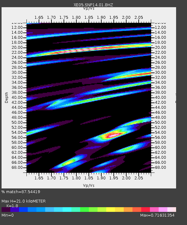
| Estimated Moho Depth: |
21.0 km |
| Estimated Crust Vp/Vs: |
1.80 |
| Assumed Crust Vp: |
6.291 km/s |
| Estimated Crust Vs: |
3.495 km/s |
| Estimated Crust Poisson's Ratio: |
0.28 |
|
| Radial Match: |
87.54419 % |
| Radial Bump: |
400 |
| Transverse Match: |
75.99032 % |
| Transverse Bump: |
400 |
| SOD ConfigId: |
268666 |
| Insert Time: |
2010-03-09 14:45:21.631 +0000 |
| GWidth: |
2.5 |
| Max Bumps: |
400 |
| Tol: |
0.001 |
|

Signal To Noise
| Channel | StoN | STA | LTA |
| XE:SNP14:01:BHZ:20070429T12:49:28.439011Z | 58.190884 | 6.611219E-6 | 1.1361262E-7 |
| XE:SNP14:01:BHN:20070429T12:49:28.439011Z | 11.533648 | 1.9306526E-6 | 1.6739307E-7 |
| XE:SNP14:01:BHE:20070429T12:49:28.439011Z | 11.231963 | 2.8455056E-6 | 2.5334003E-7 |
| Arrivals |
| Ps | 2.8 SECOND |
| PpPs | 8.8 SECOND |
| PsPs/PpSs | 12 SECOND |


