You are here: Home > Network List > TA - USArray Transportable Network (new EarthScope stations) Stations List
> Station SPMN Marine on St. Croix, MN, USA > Earthquake Result Viewer
SPMN Marine on St. Croix, MN, USA - Earthquake Result Viewer
| Earthquake location: |
Peru-Brazil Border Region |
| Earthquake latitude/longitude: |
-10.1/-71.1 |
| Earthquake time(UTC): |
2015/11/24 (328) 22:50:53 GMT |
| Earthquake Depth: |
595 km |
| Earthquake Magnitude: |
5.9 MB |
| Earthquake Catalog/Contributor: |
NEIC PDE/NEIC COMCAT |
|
| Network: |
TA USArray Transportable Network (new EarthScope stations) |
| Station: |
SPMN Marine on St. Croix, MN, USA |
| Lat/Lon: |
45.22 N/92.80 W |
| Elevation: |
311 m |
|
| Distance: |
58.5 deg |
| Az: |
342.122 deg |
| Baz: |
154.676 deg |
| Ray Param: |
0.060381066 |
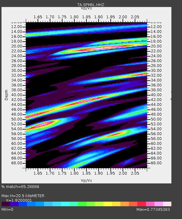
| Estimated Moho Depth: |
20.5 km |
| Estimated Crust Vp/Vs: |
1.92 |
| Assumed Crust Vp: |
6.571 km/s |
| Estimated Crust Vs: |
3.422 km/s |
| Estimated Crust Poisson's Ratio: |
0.31 |
|
| Radial Match: |
85.28886 % |
| Radial Bump: |
400 |
| Transverse Match: |
68.88567 % |
| Transverse Bump: |
400 |
| SOD ConfigId: |
7422571 |
| Insert Time: |
2019-04-21 11:51:30.894 +0000 |
| GWidth: |
2.5 |
| Max Bumps: |
400 |
| Tol: |
0.001 |
|

Signal To Noise
| Channel | StoN | STA | LTA |
| TA:SPMN: :HHZ:20151124T22:59:21.630005Z | 17.007036 | 3.079161E-5 | 1.8105217E-6 |
| TA:SPMN: :HHN:20151124T22:59:21.630005Z | 11.781349 | 3.1821524E-5 | 2.7010085E-6 |
| TA:SPMN: :HHE:20151124T22:59:21.630005Z | 8.501592 | 1.804651E-5 | 2.1227213E-6 |
| Arrivals |
| Ps | 3.0 SECOND |
| PpPs | 8.7 SECOND |
| PsPs/PpSs | 12 SECOND |


