You are here: Home > Network List > TA - USArray Transportable Network (new EarthScope stations) Stations List
> Station SPMN Marine on St. Croix, MN, USA > Earthquake Result Viewer
SPMN Marine on St. Croix, MN, USA - Earthquake Result Viewer
| Earthquake location: |
Southern Alaska |
| Earthquake latitude/longitude: |
59.7/-153.5 |
| Earthquake time(UTC): |
2016/01/24 (024) 10:30:30 GMT |
| Earthquake Depth: |
128 km |
| Earthquake Magnitude: |
7.1 MWW, 6.4 ML |
| Earthquake Catalog/Contributor: |
NEIC PDE/NEIC COMCAT |
|
| Network: |
TA USArray Transportable Network (new EarthScope stations) |
| Station: |
SPMN Marine on St. Croix, MN, USA |
| Lat/Lon: |
45.22 N/92.80 W |
| Elevation: |
311 m |
|
| Distance: |
38.2 deg |
| Az: |
84.368 deg |
| Baz: |
314.364 deg |
| Ray Param: |
0.075226955 |
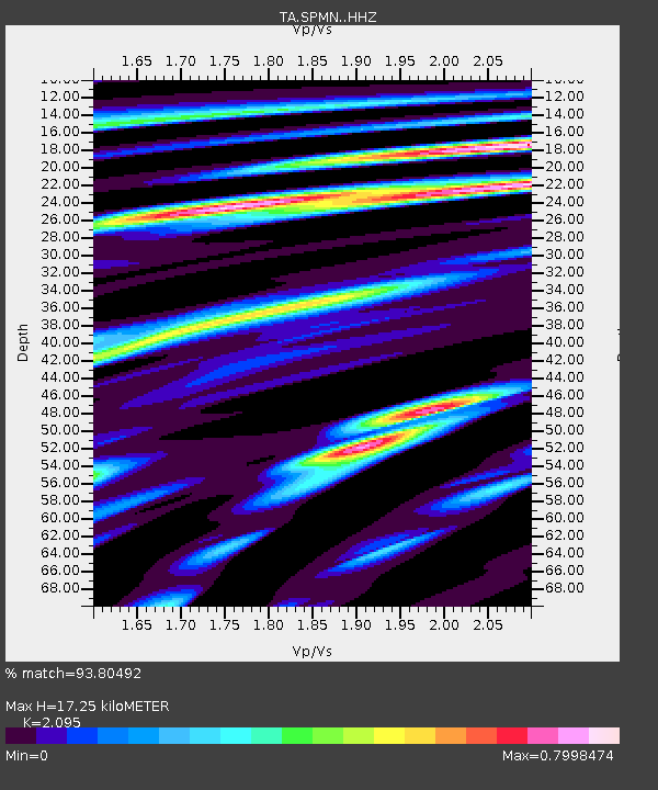
| Estimated Moho Depth: |
17.25 km |
| Estimated Crust Vp/Vs: |
2.10 |
| Assumed Crust Vp: |
6.571 km/s |
| Estimated Crust Vs: |
3.136 km/s |
| Estimated Crust Poisson's Ratio: |
0.35 |
|
| Radial Match: |
93.80492 % |
| Radial Bump: |
283 |
| Transverse Match: |
69.52824 % |
| Transverse Bump: |
400 |
| SOD ConfigId: |
7422571 |
| Insert Time: |
2019-04-21 19:46:26.442 +0000 |
| GWidth: |
2.5 |
| Max Bumps: |
400 |
| Tol: |
0.001 |
|

Signal To Noise
| Channel | StoN | STA | LTA |
| TA:SPMN: :HHZ:20160124T10:37:06.55999Z | 1.1750249 | 2.0973384E-6 | 1.7849311E-6 |
| TA:SPMN: :HHN:20160124T10:37:06.55999Z | 1.3736143 | 1.0764173E-6 | 7.8363877E-7 |
| TA:SPMN: :HHE:20160124T10:37:06.55999Z | 1.3462911 | 1.2798646E-6 | 9.506596E-7 |
| Arrivals |
| Ps | 3.1 SECOND |
| PpPs | 7.6 SECOND |
| PsPs/PpSs | 11 SECOND |


