You are here: Home > Network List > TA - USArray Transportable Network (new EarthScope stations) Stations List
> Station SPMN Marine on St. Croix, MN, USA > Earthquake Result Viewer
SPMN Marine on St. Croix, MN, USA - Earthquake Result Viewer
| Earthquake location: |
Near Coast Of Ecuador |
| Earthquake latitude/longitude: |
0.7/-80.0 |
| Earthquake time(UTC): |
2016/04/20 (111) 08:35:10 GMT |
| Earthquake Depth: |
10 km |
| Earthquake Magnitude: |
6.0 MWB |
| Earthquake Catalog/Contributor: |
NEIC PDE/NEIC COMCAT |
|
| Network: |
TA USArray Transportable Network (new EarthScope stations) |
| Station: |
SPMN Marine on St. Croix, MN, USA |
| Lat/Lon: |
45.22 N/92.80 W |
| Elevation: |
311 m |
|
| Distance: |
45.7 deg |
| Az: |
347.379 deg |
| Baz: |
161.992 deg |
| Ray Param: |
0.07107336 |
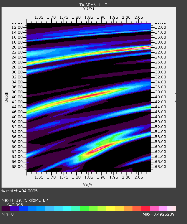
| Estimated Moho Depth: |
19.75 km |
| Estimated Crust Vp/Vs: |
2.10 |
| Assumed Crust Vp: |
6.571 km/s |
| Estimated Crust Vs: |
3.136 km/s |
| Estimated Crust Poisson's Ratio: |
0.35 |
|
| Radial Match: |
94.0085 % |
| Radial Bump: |
228 |
| Transverse Match: |
55.173367 % |
| Transverse Bump: |
400 |
| SOD ConfigId: |
7422571 |
| Insert Time: |
2019-04-22 10:00:39.863 +0000 |
| GWidth: |
2.5 |
| Max Bumps: |
400 |
| Tol: |
0.001 |
|

Signal To Noise
| Channel | StoN | STA | LTA |
| TA:SPMN: :HHZ:20160420T08:43:01.070006Z | 3.0400355 | 7.5500395E-7 | 2.4835367E-7 |
| TA:SPMN: :HHN:20160420T08:43:01.070006Z | 2.9604414 | 6.017999E-7 | 2.0328046E-7 |
| TA:SPMN: :HHE:20160420T08:43:01.070006Z | 1.0503159 | 1.4227722E-7 | 1.3546136E-7 |
| Arrivals |
| Ps | 3.5 SECOND |
| PpPs | 8.8 SECOND |
| PsPs/PpSs | 12 SECOND |


