You are here: Home > Network List > TA - USArray Transportable Network (new EarthScope stations) Stations List
> Station SPMN Marine on St. Croix, MN, USA > Earthquake Result Viewer
SPMN Marine on St. Croix, MN, USA - Earthquake Result Viewer
| Earthquake location: |
Northern East Pacific Rise |
| Earthquake latitude/longitude: |
10.3/-103.8 |
| Earthquake time(UTC): |
2016/04/29 (120) 01:33:38 GMT |
| Earthquake Depth: |
10 km |
| Earthquake Magnitude: |
6.8 MWP, 6.9 MI |
| Earthquake Catalog/Contributor: |
NEIC PDE/NEIC COMCAT |
|
| Network: |
TA USArray Transportable Network (new EarthScope stations) |
| Station: |
SPMN Marine on St. Croix, MN, USA |
| Lat/Lon: |
45.22 N/92.80 W |
| Elevation: |
311 m |
|
| Distance: |
36.1 deg |
| Az: |
13.179 deg |
| Baz: |
198.514 deg |
| Ray Param: |
0.0768646 |
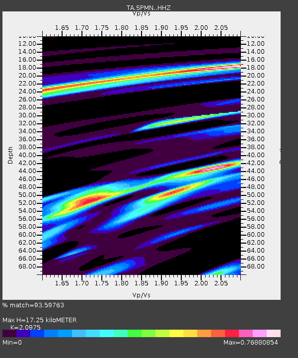
| Estimated Moho Depth: |
17.25 km |
| Estimated Crust Vp/Vs: |
2.10 |
| Assumed Crust Vp: |
6.571 km/s |
| Estimated Crust Vs: |
3.133 km/s |
| Estimated Crust Poisson's Ratio: |
0.35 |
|
| Radial Match: |
93.59763 % |
| Radial Bump: |
212 |
| Transverse Match: |
63.595535 % |
| Transverse Bump: |
400 |
| SOD ConfigId: |
7422571 |
| Insert Time: |
2019-04-22 12:11:30.666 +0000 |
| GWidth: |
2.5 |
| Max Bumps: |
400 |
| Tol: |
0.001 |
|

Signal To Noise
| Channel | StoN | STA | LTA |
| TA:SPMN: :HHZ:20160429T01:40:09.790001Z | 9.95398 | 1.3692785E-6 | 1.375609E-7 |
| TA:SPMN: :HHN:20160429T01:40:09.790001Z | 8.887796 | 9.1600384E-7 | 1.030631E-7 |
| TA:SPMN: :HHE:20160429T01:40:09.790001Z | 3.1227634 | 3.3159515E-7 | 1.0618644E-7 |
| Arrivals |
| Ps | 3.1 SECOND |
| PpPs | 7.6 SECOND |
| PsPs/PpSs | 11 SECOND |


