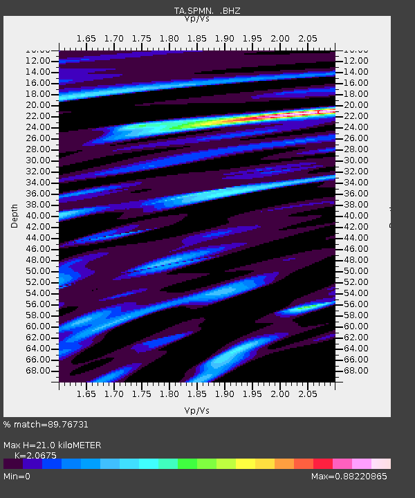
SPMN Marine on St. Croix, MN, USA - Earthquake Result Viewer

Earthquake location: Rat Islands, Aleutian Islands
Earthquake latitude/longitude: 50.4/177.0
Earthquake time(UTC): 2009/07/06 (187) 14:53:12 GMT
Earthquake Depth: 22 km
Earthquake Magnitude: 6.0 MB, 5.8 MS, 6.1 MW, 6.0 MW
Earthquake Catalog/Contributor: WHDF/NEIC
Network: TA USArray Transportable Network (new EarthScope stations)
Station: SPMN Marine on St. Croix, MN, USA
Lat/Lon: 45.22 N/92.80 W
Elevation: 311 m
Distance: 57.2 deg
Az: 57.261 deg
Baz: 310.435 deg
Ray Param: 0.06364055
Estimated Moho Depth: 21.0 km
Estimated Crust Vp/Vs: 2.07
Assumed Crust Vp: 6.571 km/s
Estimated Crust Vs: 3.178 km/s
Estimated Crust Poisson's Ratio: 0.35
Radial Match: 89.76731 %
Radial Bump: 400
Transverse Match: 78.9939 %
Transverse Bump: 400
SOD ConfigId: 2622
Insert Time: 2010-03-06 03:18:37.369 +0000
GWidth: 2.5
Max Bumps: 400
Tol: 0.001

Signal To Noise

ChannelStoNSTALTA
TA:SPMN: :BHZ:20090706T15:02:26.299021Z25.8290732.9929658E-61.1587586E-7
TA:SPMN: :BHN:20090706T15:02:26.299021Z7.3934181.3414648E-61.8144041E-7
TA:SPMN: :BHE:20090706T15:02:26.299021Z6.9406331.5306042E-62.2052805E-7
Arrivals
Ps3.6 SECOND
PpPs9.4 SECOND
PsPs/PpSs13 SECOND