You are here: Home > Network List > TA - USArray Transportable Network (new EarthScope stations) Stations List
> Station SPMN Marine on St. Croix, MN, USA > Earthquake Result Viewer
SPMN Marine on St. Croix, MN, USA - Earthquake Result Viewer
| Earthquake location: |
Tonga Islands |
| Earthquake latitude/longitude: |
-15.4/-173.2 |
| Earthquake time(UTC): |
2009/09/29 (272) 18:40:09 GMT |
| Earthquake Depth: |
2.3 km |
| Earthquake Magnitude: |
5.5 MB |
| Earthquake Catalog/Contributor: |
WHDF/NEIC |
|
| Network: |
TA USArray Transportable Network (new EarthScope stations) |
| Station: |
SPMN Marine on St. Croix, MN, USA |
| Lat/Lon: |
45.22 N/92.80 W |
| Elevation: |
311 m |
|
| Distance: |
94.2 deg |
| Az: |
44.326 deg |
| Baz: |
252.529 deg |
| Ray Param: |
0.04110739 |
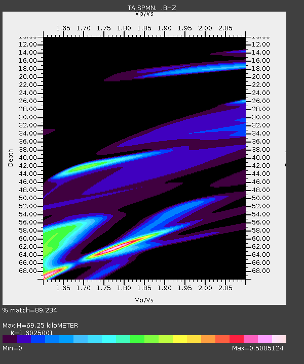
| Estimated Moho Depth: |
69.25 km |
| Estimated Crust Vp/Vs: |
1.60 |
| Assumed Crust Vp: |
6.571 km/s |
| Estimated Crust Vs: |
4.1 km/s |
| Estimated Crust Poisson's Ratio: |
0.18 |
|
| Radial Match: |
89.234 % |
| Radial Bump: |
400 |
| Transverse Match: |
50.861576 % |
| Transverse Bump: |
400 |
| SOD ConfigId: |
2622 |
| Insert Time: |
2010-03-06 03:18:48.640 +0000 |
| GWidth: |
2.5 |
| Max Bumps: |
400 |
| Tol: |
0.001 |
|

Signal To Noise
| Channel | StoN | STA | LTA |
| TA:SPMN: :BHZ:20090929T18:52:58.249011Z | 0.65063024 | 2.7785376E-5 | 4.2705327E-5 |
| TA:SPMN: :BHN:20090929T18:52:58.249011Z | 1.7919264 | 1.3170057E-5 | 7.349664E-6 |
| TA:SPMN: :BHE:20090929T18:52:58.249011Z | 1.4361285 | 3.3858112E-5 | 2.3575962E-5 |
| Arrivals |
| Ps | 6.5 SECOND |
| PpPs | 27 SECOND |
| PsPs/PpSs | 33 SECOND |


