You are here: Home > Network List > TA - USArray Transportable Network (new EarthScope stations) Stations List
> Station SPMN Marine on St. Croix, MN, USA > Earthquake Result Viewer
SPMN Marine on St. Croix, MN, USA - Earthquake Result Viewer
| Earthquake location: |
Costa Rica |
| Earthquake latitude/longitude: |
8.5/-83.2 |
| Earthquake time(UTC): |
2009/03/11 (070) 17:24:36 GMT |
| Earthquake Depth: |
14 km |
| Earthquake Magnitude: |
5.8 MB, 5.6 MS, 5.9 MW, 5.9 MW |
| Earthquake Catalog/Contributor: |
WHDF/NEIC |
|
| Network: |
TA USArray Transportable Network (new EarthScope stations) |
| Station: |
SPMN Marine on St. Croix, MN, USA |
| Lat/Lon: |
45.22 N/92.80 W |
| Elevation: |
311 m |
|
| Distance: |
37.5 deg |
| Az: |
348.858 deg |
| Baz: |
164.308 deg |
| Ray Param: |
0.07608573 |
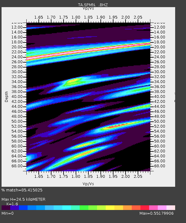
| Estimated Moho Depth: |
24.5 km |
| Estimated Crust Vp/Vs: |
1.60 |
| Assumed Crust Vp: |
6.571 km/s |
| Estimated Crust Vs: |
4.107 km/s |
| Estimated Crust Poisson's Ratio: |
0.18 |
|
| Radial Match: |
85.415825 % |
| Radial Bump: |
329 |
| Transverse Match: |
50.82467 % |
| Transverse Bump: |
400 |
| SOD ConfigId: |
2658 |
| Insert Time: |
2010-03-06 03:19:05.932 +0000 |
| GWidth: |
2.5 |
| Max Bumps: |
400 |
| Tol: |
0.001 |
|

Signal To Noise
| Channel | StoN | STA | LTA |
| TA:SPMN: :BHZ:20090311T17:31:19.125015Z | 10.3900795 | 1.5287671E-6 | 1.4713719E-7 |
| TA:SPMN: :BHN:20090311T17:31:19.125015Z | 4.430897 | 1.0134901E-6 | 2.2873247E-7 |
| TA:SPMN: :BHE:20090311T17:31:19.125015Z | 1.8925873 | 3.3881707E-7 | 1.7902322E-7 |
| Arrivals |
| Ps | 2.4 SECOND |
| PpPs | 8.9 SECOND |
| PsPs/PpSs | 11 SECOND |


