You are here: Home > Network List > TA - USArray Transportable Network (new EarthScope stations) Stations List
> Station SPMN Marine on St. Croix, MN, USA > Earthquake Result Viewer
SPMN Marine on St. Croix, MN, USA - Earthquake Result Viewer
| Earthquake location: |
Near Coast Of Chiapas, Mexico |
| Earthquake latitude/longitude: |
15.1/-93.7 |
| Earthquake time(UTC): |
2017/09/08 (251) 04:49:21 GMT |
| Earthquake Depth: |
70 km |
| Earthquake Magnitude: |
8.1 Mww |
| Earthquake Catalog/Contributor: |
NEIC PDE/us |
|
| Network: |
TA USArray Transportable Network (new EarthScope stations) |
| Station: |
SPMN Marine on St. Croix, MN, USA |
| Lat/Lon: |
45.22 N/92.80 W |
| Elevation: |
311 m |
|
| Distance: |
30.1 deg |
| Az: |
1.285 deg |
| Baz: |
181.757 deg |
| Ray Param: |
0.07932539 |
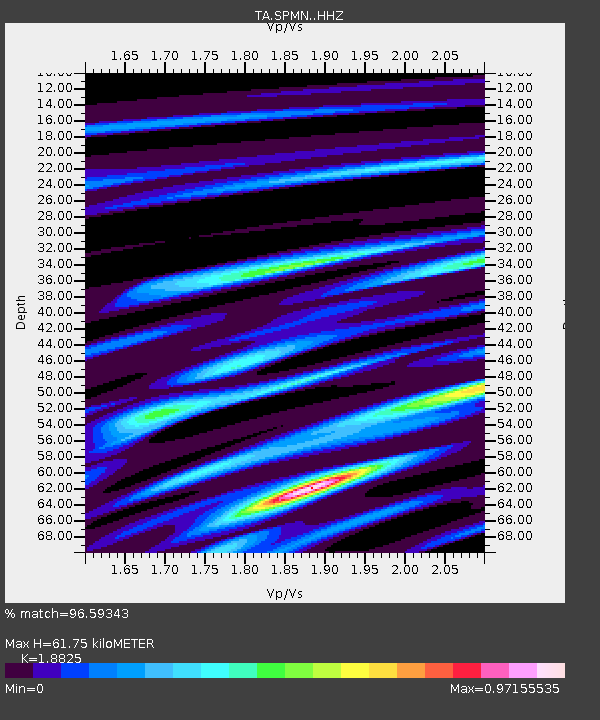
| Estimated Moho Depth: |
61.75 km |
| Estimated Crust Vp/Vs: |
1.88 |
| Assumed Crust Vp: |
6.571 km/s |
| Estimated Crust Vs: |
3.49 km/s |
| Estimated Crust Poisson's Ratio: |
0.30 |
|
| Radial Match: |
96.59343 % |
| Radial Bump: |
299 |
| Transverse Match: |
79.13685 % |
| Transverse Bump: |
400 |
| SOD ConfigId: |
13570011 |
| Insert Time: |
2019-04-28 17:29:32.231 +0000 |
| GWidth: |
2.5 |
| Max Bumps: |
400 |
| Tol: |
0.001 |
|

Signal To Noise
| Channel | StoN | STA | LTA |
| TA:SPMN: :HHZ:20170908T04:54:54.029995Z | 15.162799 | 3.1953394E-5 | 2.1073545E-6 |
| TA:SPMN: :HHN:20170908T04:54:54.029995Z | 16.109722 | 2.318736E-5 | 1.4393396E-6 |
| TA:SPMN: :HHE:20170908T04:54:54.029995Z | 22.970964 | 3.3685774E-6 | 1.4664501E-7 |
| Arrivals |
| Ps | 9.0 SECOND |
| PpPs | 25 SECOND |
| PsPs/PpSs | 34 SECOND |


