You are here: Home > Network List > TA - USArray Transportable Network (new EarthScope stations) Stations List
> Station SPMN Marine on St. Croix, MN, USA > Earthquake Result Viewer
SPMN Marine on St. Croix, MN, USA - Earthquake Result Viewer
| Earthquake location: |
Costa Rica |
| Earthquake latitude/longitude: |
9.3/-84.2 |
| Earthquake time(UTC): |
2010/06/01 (152) 03:26:15 GMT |
| Earthquake Depth: |
18 km |
| Earthquake Magnitude: |
5.7 MB, 5.6 MS, 6.0 MW, 5.9 MW |
| Earthquake Catalog/Contributor: |
WHDF/NEIC |
|
| Network: |
TA USArray Transportable Network (new EarthScope stations) |
| Station: |
SPMN Marine on St. Croix, MN, USA |
| Lat/Lon: |
45.22 N/92.80 W |
| Elevation: |
311 m |
|
| Distance: |
36.5 deg |
| Az: |
349.775 deg |
| Baz: |
165.646 deg |
| Ray Param: |
0.07661426 |
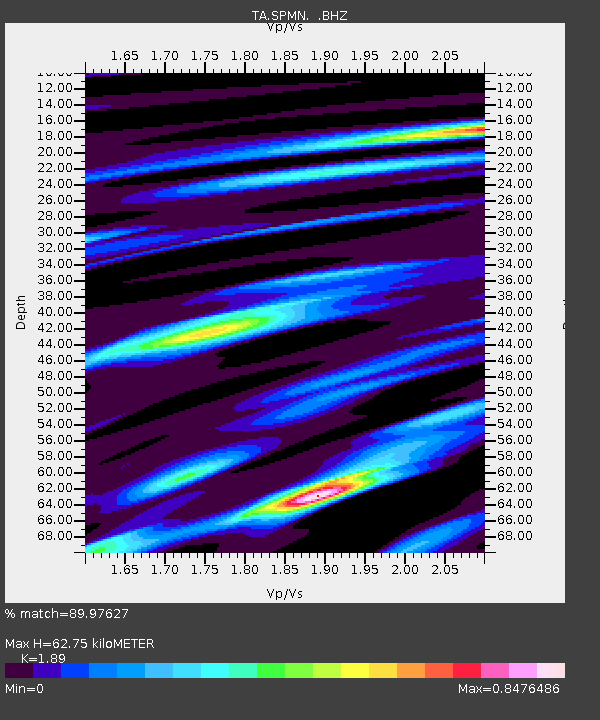
| Estimated Moho Depth: |
62.75 km |
| Estimated Crust Vp/Vs: |
1.89 |
| Assumed Crust Vp: |
6.571 km/s |
| Estimated Crust Vs: |
3.477 km/s |
| Estimated Crust Poisson's Ratio: |
0.31 |
|
| Radial Match: |
89.97627 % |
| Radial Bump: |
231 |
| Transverse Match: |
50.371704 % |
| Transverse Bump: |
400 |
| SOD ConfigId: |
317696 |
| Insert Time: |
2010-09-19 07:04:04.376 +0000 |
| GWidth: |
2.5 |
| Max Bumps: |
400 |
| Tol: |
0.001 |
|

Signal To Noise
| Channel | StoN | STA | LTA |
| TA:SPMN: :BHZ:20100601T03:32:49.349996Z | 3.7536323 | 6.0904944E-7 | 1.6225601E-7 |
| TA:SPMN: :BHN:20100601T03:32:49.349996Z | 2.9204967 | 5.6888723E-7 | 1.9479126E-7 |
| TA:SPMN: :BHE:20100601T03:32:49.349996Z | 1.1736624 | 2.0843868E-7 | 1.7759677E-7 |
| Arrivals |
| Ps | 9.1 SECOND |
| PpPs | 26 SECOND |
| PsPs/PpSs | 35 SECOND |


