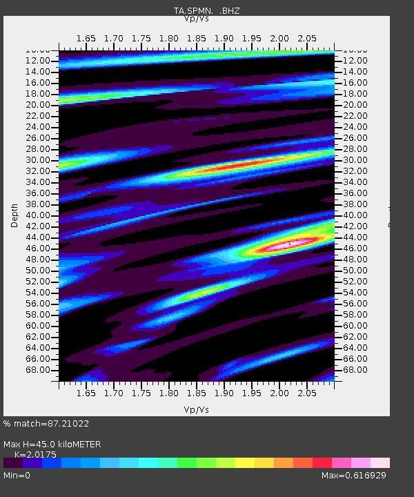
SPMN Marine on St. Croix, MN, USA - Earthquake Result Viewer

Earthquake location: Near East Coast Of Honshu, Japan
Earthquake latitude/longitude: 38.4/142.8
Earthquake time(UTC): 2011/03/09 (068) 02:45:20 GMT
Earthquake Depth: 32 km
Earthquake Magnitude: 6.4 MB, 7.3 MS, 7.5 MW, 7.3 MW
Earthquake Catalog/Contributor: WHDF/NEIC
Network: TA USArray Transportable Network (new EarthScope stations)
Station: SPMN Marine on St. Croix, MN, USA
Lat/Lon: 45.22 N/92.80 W
Elevation: 311 m
Distance: 82.8 deg
Az: 36.017 deg
Baz: 319.197 deg
Ray Param: 0.046572484
Estimated Moho Depth: 45.0 km
Estimated Crust Vp/Vs: 2.02
Assumed Crust Vp: 6.571 km/s
Estimated Crust Vs: 3.257 km/s
Estimated Crust Poisson's Ratio: 0.34
Radial Match: 87.21022 %
Radial Bump: 400
Transverse Match: 53.282654 %
Transverse Bump: 400
SOD ConfigId: 354511
Insert Time: 2011-08-09 12:09:23.396 +0000
GWidth: 2.5
Max Bumps: 400
Tol: 0.001

Signal To Noise

ChannelStoNSTALTA
TA:SPMN: :BHZ:20110309T02:57:10.275007Z3.61838481.0134088E-62.8007216E-7
TA:SPMN: :BHN:20110309T02:57:10.275007Z0.997774842.8535788E-72.8599428E-7
TA:SPMN: :BHE:20110309T02:57:10.275007Z1.35320913.5871582E-72.6508528E-7
Arrivals
Ps7.1 SECOND
PpPs20 SECOND
PsPs/PpSs27 SECOND