You are here: Home > Network List > TA - USArray Transportable Network (new EarthScope stations) Stations List
> Station SPMN Marine on St. Croix, MN, USA > Earthquake Result Viewer
SPMN Marine on St. Croix, MN, USA - Earthquake Result Viewer
| Earthquake location: |
South Of Panama |
| Earthquake latitude/longitude: |
6.9/-82.3 |
| Earthquake time(UTC): |
2011/04/30 (120) 08:19:16 GMT |
| Earthquake Depth: |
8.0 km |
| Earthquake Magnitude: |
5.8 MB, 5.7 MS, 6.2 MW, 6.0 MW |
| Earthquake Catalog/Contributor: |
WHDF/NEIC |
|
| Network: |
TA USArray Transportable Network (new EarthScope stations) |
| Station: |
SPMN Marine on St. Croix, MN, USA |
| Lat/Lon: |
45.22 N/92.80 W |
| Elevation: |
311 m |
|
| Distance: |
39.3 deg |
| Az: |
348.3 deg |
| Baz: |
163.445 deg |
| Ray Param: |
0.07507131 |
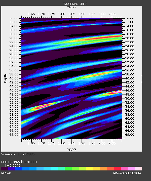
| Estimated Moho Depth: |
46.0 km |
| Estimated Crust Vp/Vs: |
2.10 |
| Assumed Crust Vp: |
6.571 km/s |
| Estimated Crust Vs: |
3.133 km/s |
| Estimated Crust Poisson's Ratio: |
0.35 |
|
| Radial Match: |
81.910385 % |
| Radial Bump: |
395 |
| Transverse Match: |
51.146664 % |
| Transverse Bump: |
400 |
| SOD ConfigId: |
356183 |
| Insert Time: |
2011-10-06 04:56:16.796 +0000 |
| GWidth: |
2.5 |
| Max Bumps: |
400 |
| Tol: |
0.001 |
|

Signal To Noise
| Channel | StoN | STA | LTA |
| TA:SPMN: :BHZ:20110430T08:26:14.499993Z | 9.429286 | 7.9026256E-7 | 8.3809375E-8 |
| TA:SPMN: :BHN:20110430T08:26:14.499993Z | 4.7613134 | 5.4236676E-7 | 1.1391117E-7 |
| TA:SPMN: :BHE:20110430T08:26:14.499993Z | 2.8509252 | 2.6862566E-7 | 9.422403E-8 |
| Arrivals |
| Ps | 8.2 SECOND |
| PpPs | 20 SECOND |
| PsPs/PpSs | 29 SECOND |


