You are here: Home > Network List > TA - USArray Transportable Network (new EarthScope stations) Stations List
> Station SPMN Marine on St. Croix, MN, USA > Earthquake Result Viewer
SPMN Marine on St. Croix, MN, USA - Earthquake Result Viewer
| Earthquake location: |
Alaska Peninsula |
| Earthquake latitude/longitude: |
54.8/-161.3 |
| Earthquake time(UTC): |
2011/07/16 (197) 19:59:12 GMT |
| Earthquake Depth: |
36 km |
| Earthquake Magnitude: |
6.3 MB, 5.9 MS, 6.2 MW, 6.1 MW |
| Earthquake Catalog/Contributor: |
WHDF/NEIC |
|
| Network: |
TA USArray Transportable Network (new EarthScope stations) |
| Station: |
SPMN Marine on St. Croix, MN, USA |
| Lat/Lon: |
45.22 N/92.80 W |
| Elevation: |
311 m |
|
| Distance: |
43.4 deg |
| Az: |
73.199 deg |
| Baz: |
308.317 deg |
| Ray Param: |
0.07251409 |
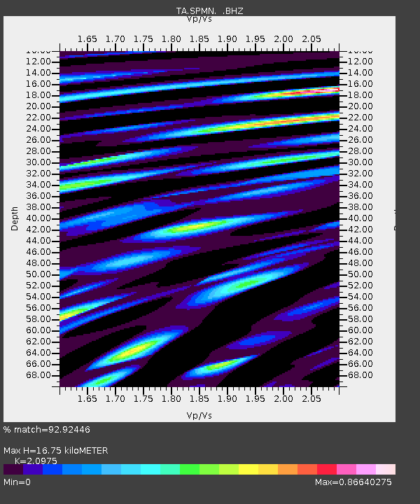
| Estimated Moho Depth: |
16.75 km |
| Estimated Crust Vp/Vs: |
2.10 |
| Assumed Crust Vp: |
6.571 km/s |
| Estimated Crust Vs: |
3.133 km/s |
| Estimated Crust Poisson's Ratio: |
0.35 |
|
| Radial Match: |
92.92446 % |
| Radial Bump: |
400 |
| Transverse Match: |
80.17547 % |
| Transverse Bump: |
400 |
| SOD ConfigId: |
401841 |
| Insert Time: |
2011-12-21 03:31:48.807 +0000 |
| GWidth: |
2.5 |
| Max Bumps: |
400 |
| Tol: |
0.001 |
|

Signal To Noise
| Channel | StoN | STA | LTA |
| TA:SPMN: :BHZ:20110716T20:06:41.324998Z | 13.671424 | 1.2873297E-6 | 9.4162075E-8 |
| TA:SPMN: :BHN:20110716T20:06:41.324998Z | 4.315038 | 4.5833258E-7 | 1.06217506E-7 |
| TA:SPMN: :BHE:20110716T20:06:41.324998Z | 6.9929504 | 6.376803E-7 | 9.1189015E-8 |
| Arrivals |
| Ps | 3.0 SECOND |
| PpPs | 7.4 SECOND |
| PsPs/PpSs | 10 SECOND |


