You are here: Home > Network List > TA - USArray Transportable Network (new EarthScope stations) Stations List
> Station SPMN Marine on St. Croix, MN, USA > Earthquake Result Viewer
SPMN Marine on St. Croix, MN, USA - Earthquake Result Viewer
| Earthquake location: |
Nicaragua |
| Earthquake latitude/longitude: |
11.6/-85.9 |
| Earthquake time(UTC): |
2011/11/07 (311) 22:35:25 GMT |
| Earthquake Depth: |
177 km |
| Earthquake Magnitude: |
6.0 MB, 6.0 MW, 6.1 MW |
| Earthquake Catalog/Contributor: |
WHDF/NEIC |
|
| Network: |
TA USArray Transportable Network (new EarthScope stations) |
| Station: |
SPMN Marine on St. Croix, MN, USA |
| Lat/Lon: |
45.22 N/92.80 W |
| Elevation: |
311 m |
|
| Distance: |
34.1 deg |
| Az: |
351.229 deg |
| Baz: |
167.793 deg |
| Ray Param: |
0.07731483 |
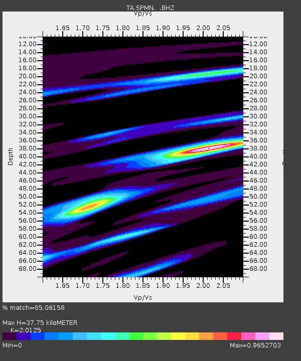
| Estimated Moho Depth: |
37.75 km |
| Estimated Crust Vp/Vs: |
2.01 |
| Assumed Crust Vp: |
6.571 km/s |
| Estimated Crust Vs: |
3.265 km/s |
| Estimated Crust Poisson's Ratio: |
0.34 |
|
| Radial Match: |
85.06159 % |
| Radial Bump: |
336 |
| Transverse Match: |
77.736206 % |
| Transverse Bump: |
389 |
| SOD ConfigId: |
424168 |
| Insert Time: |
2012-02-24 05:40:16.806 +0000 |
| GWidth: |
2.5 |
| Max Bumps: |
400 |
| Tol: |
0.001 |
|

Signal To Noise
| Channel | StoN | STA | LTA |
| TA:SPMN: :BHZ:20111107T22:41:22.749995Z | 8.054908 | 3.0566155E-6 | 3.7947245E-7 |
| TA:SPMN: :BHN:20111107T22:41:22.749995Z | 3.9010644 | 2.1849787E-6 | 5.600981E-7 |
| TA:SPMN: :BHE:20111107T22:41:22.749995Z | 2.1888394 | 1.0518874E-6 | 4.8056853E-7 |
| Arrivals |
| Ps | 6.2 SECOND |
| PpPs | 16 SECOND |
| PsPs/PpSs | 22 SECOND |


