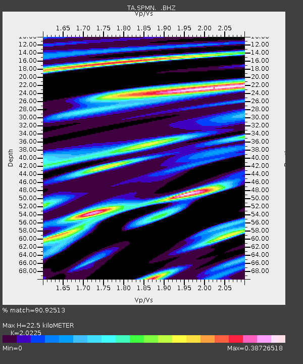
SPMN Marine on St. Croix, MN, USA - Earthquake Result Viewer

Earthquake location: Andreanof Islands, Aleutian Is.
Earthquake latitude/longitude: 51.6/-178.3
Earthquake time(UTC): 2012/09/26 (270) 23:39:55 GMT
Earthquake Depth: 16 km
Earthquake Magnitude: 6.3 MB, 6.5 MS, 6.4 MW, 6.4 MW
Earthquake Catalog/Contributor: WHDF/NEIC
Network: TA USArray Transportable Network (new EarthScope stations)
Station: SPMN Marine on St. Croix, MN, USA
Lat/Lon: 45.22 N/92.80 W
Elevation: 311 m
Distance: 54.0 deg
Az: 60.541 deg
Baz: 309.773 deg
Ray Param: 0.065700315
Estimated Moho Depth: 22.5 km
Estimated Crust Vp/Vs: 2.02
Assumed Crust Vp: 6.571 km/s
Estimated Crust Vs: 3.249 km/s
Estimated Crust Poisson's Ratio: 0.34
Radial Match: 90.92513 %
Radial Bump: 342
Transverse Match: 74.63263 %
Transverse Bump: 400
SOD ConfigId: 478790
Insert Time: 2013-02-22 23:16:55.186 +0000
GWidth: 2.5
Max Bumps: 400
Tol: 0.001

Signal To Noise

ChannelStoNSTALTA
TA:SPMN: :BHZ:20120926T23:48:47.375015Z7.8687061.0011249E-61.2722865E-7
TA:SPMN: :BHN:20120926T23:48:47.375015Z2.47821973.6703983E-71.4810625E-7
TA:SPMN: :BHE:20120926T23:48:47.375015Z4.6299095.115982E-71.1049854E-7
Arrivals
Ps3.7 SECOND
PpPs9.9 SECOND
PsPs/PpSs14 SECOND