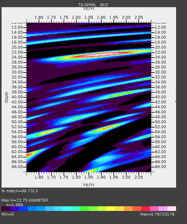
SPMN Marine on St. Croix, MN, USA - Earthquake Result Viewer

Earthquake location: Andreanof Islands, Aleutian Is.
Earthquake latitude/longitude: 51.5/-175.2
Earthquake time(UTC): 2013/08/30 (242) 16:25:02 GMT
Earthquake Depth: 29 km
Earthquake Magnitude: 7.0 MWW, 6.5 ML, 6.8 MI, 6.9 MWC, 6.9 MWB, 7.0 MWW, 7.0 MI, 7.0 MWC
Earthquake Catalog/Contributor: NEIC PDE/NEIC COMCAT
Network: TA USArray Transportable Network (new EarthScope stations)
Station: SPMN Marine on St. Croix, MN, USA
Lat/Lon: 45.22 N/92.80 W
Elevation: 311 m
Distance: 52.4 deg
Az: 62.214 deg
Baz: 308.568 deg
Ray Param: 0.06676078
Estimated Moho Depth: 22.75 km
Estimated Crust Vp/Vs: 1.89
Assumed Crust Vp: 6.571 km/s
Estimated Crust Vs: 3.467 km/s
Estimated Crust Poisson's Ratio: 0.31
Radial Match: 96.7313 %
Radial Bump: 400
Transverse Match: 80.23213 %
Transverse Bump: 400
SOD ConfigId: 626651
Insert Time: 2014-04-18 05:27:07.233 +0000
GWidth: 2.5
Max Bumps: 400
Tol: 0.001

Signal To Noise

ChannelStoNSTALTA
TA:SPMN: :BHZ:20130830T16:33:40.849988Z20.2279532.3510106E-61.16225834E-7
TA:SPMN: :BHN:20130830T16:33:40.849988Z4.89358668.3688394E-71.7101647E-7
TA:SPMN: :BHE:20130830T16:33:40.849988Z7.93671371.2312915E-61.5513871E-7
Arrivals
Ps3.3 SECOND
PpPs9.5 SECOND
PsPs/PpSs13 SECOND