SPMN Marine on St. Croix, MN, USA - Earthquake Result Viewer
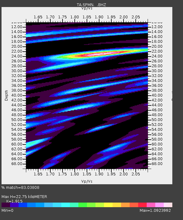
Earthquake location: Andreanof Islands, Aleutian Is.
Earthquake latitude/longitude: 51.6/-174.8
Earthquake time(UTC): 2013/09/04 (247) 02:32:30 GMT
Earthquake Depth: 20 km
Earthquake Magnitude: 6.5 MWW, 5.9 ML, 6.3 MWB, 6.5 MI, 6.5 MWC, 6.5 MWW
Earthquake Catalog/Contributor: NEIC PDE/NEIC COMCAT
Network: TA USArray Transportable Network (new EarthScope stations)
Station: SPMN Marine on St. Croix, MN, USA
Lat/Lon: 45.22 N/92.80 W
Elevation: 311 m
Distance: 52.1 deg
Az: 62.485 deg
Baz: 308.421 deg
Ray Param: 0.06695558
Estimated Moho Depth: 22.75 km
Estimated Crust Vp/Vs: 1.91
Assumed Crust Vp: 6.571 km/s
Estimated Crust Vs: 3.431 km/s
Estimated Crust Poisson's Ratio: 0.31
Radial Match: 83.03808 %
Radial Bump: 400
Transverse Match: 57.123928 %
Transverse Bump: 400
SOD ConfigId: 626651
Insert Time: 2014-04-18 10:20:52.269 +0000
GWidth: 2.5
Max Bumps: 400
Tol: 0.001

Signal To Noise

ChannelStoNSTALTA
TA:SPMN: :BHZ:20130904T02:41:08.250024Z6.7062661.032785E-61.5400298E-7
TA:SPMN: :BHN:20130904T02:41:08.250024Z3.08158833.2185443E-71.0444433E-7
TA:SPMN: :BHE:20130904T02:41:08.250024Z3.712074.435156E-71.1947931E-7
Arrivals
Ps3.3 SECOND
PpPs9.6 SECOND
PsPs/PpSs13 SECOND