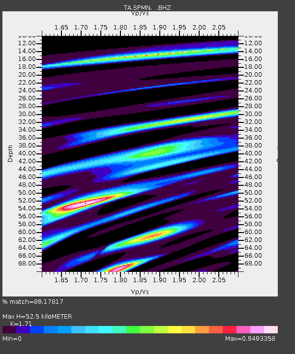
SPMN Marine on St. Croix, MN, USA - Earthquake Result Viewer

Earthquake location: Near Coast Of Chiapas, Mexico
Earthquake latitude/longitude: 14.6/-92.1
Earthquake time(UTC): 2013/09/07 (250) 00:13:29 GMT
Earthquake Depth: 66 km
Earthquake Magnitude: 6.4 MWW, 6.4 MWB, 6.4 MWC, 6.4 MWW, 6.5 MWC
Earthquake Catalog/Contributor: NEIC PDE/NEIC COMCAT
Network: TA USArray Transportable Network (new EarthScope stations)
Station: SPMN Marine on St. Croix, MN, USA
Lat/Lon: 45.22 N/92.80 W
Elevation: 311 m
Distance: 30.5 deg
Az: 359.05 deg
Baz: 178.698 deg
Ray Param: 0.079213396
Estimated Moho Depth: 52.5 km
Estimated Crust Vp/Vs: 1.71
Assumed Crust Vp: 6.571 km/s
Estimated Crust Vs: 3.842 km/s
Estimated Crust Poisson's Ratio: 0.24
Radial Match: 89.17817 %
Radial Bump: 400
Transverse Match: 68.29965 %
Transverse Bump: 400
SOD ConfigId: 626651
Insert Time: 2014-04-18 15:10:02.352 +0000
GWidth: 2.5
Max Bumps: 400
Tol: 0.001

Signal To Noise

ChannelStoNSTALTA
TA:SPMN: :BHZ:20130907T00:19:06.399987Z3.88011774.194593E-71.0810479E-7
TA:SPMN: :BHN:20130907T00:19:06.399987Z2.03629143.600204E-71.76802E-7
TA:SPMN: :BHE:20130907T00:19:06.399987Z1.114261.3962281E-71.2530542E-7
Arrivals
Ps6.2 SECOND
PpPs20 SECOND
PsPs/PpSs26 SECOND