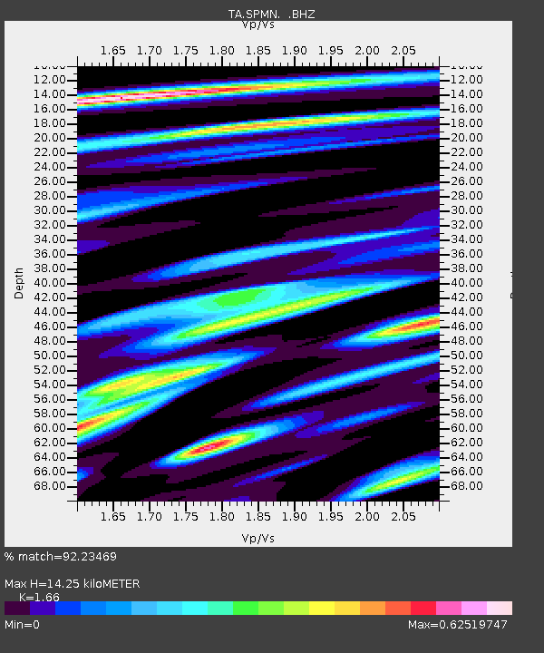
SPMN Marine on St. Croix, MN, USA - Earthquake Result Viewer

Earthquake location: Near Coast Of Central Chile
Earthquake latitude/longitude: -30.3/-71.5
Earthquake time(UTC): 2013/10/31 (304) 23:03:59 GMT
Earthquake Depth: 27 km
Earthquake Magnitude: 6.6 MWW, 6.4 MWB, 6.5 MWC, 6.6 MWW, 6.6 MI
Earthquake Catalog/Contributor: NEIC PDE/NEIC COMCAT
Network: TA USArray Transportable Network (new EarthScope stations)
Station: SPMN Marine on St. Croix, MN, USA
Lat/Lon: 45.22 N/92.80 W
Elevation: 311 m
Distance: 77.6 deg
Az: 344.774 deg
Baz: 161.251 deg
Ray Param: 0.050168768
Estimated Moho Depth: 14.25 km
Estimated Crust Vp/Vs: 1.66
Assumed Crust Vp: 6.571 km/s
Estimated Crust Vs: 3.958 km/s
Estimated Crust Poisson's Ratio: 0.22
Radial Match: 92.23469 %
Radial Bump: 400
Transverse Match: 79.42894 %
Transverse Bump: 400
SOD ConfigId: 626651
Insert Time: 2014-04-19 09:21:34.665 +0000
GWidth: 2.5
Max Bumps: 400
Tol: 0.001

Signal To Noise

ChannelStoNSTALTA
TA:SPMN: :BHZ:20131031T23:15:22.250029Z3.0404544.724475E-71.5538717E-7
TA:SPMN: :BHN:20131031T23:15:22.250029Z1.49366862.5055905E-71.6774743E-7
TA:SPMN: :BHE:20131031T23:15:22.250029Z1.06464991.6356283E-71.5363061E-7
Arrivals
Ps1.5 SECOND
PpPs5.6 SECOND
PsPs/PpSs7.1 SECOND