You are here: Home > Network List > TA - USArray Transportable Network (new EarthScope stations) Stations List
> Station SPMN Marine on St. Croix, MN, USA > Earthquake Result Viewer
SPMN Marine on St. Croix, MN, USA - Earthquake Result Viewer
| Earthquake location: |
North Atlantic Ocean |
| Earthquake latitude/longitude: |
14.7/-58.9 |
| Earthquake time(UTC): |
2014/02/18 (049) 09:27:13 GMT |
| Earthquake Depth: |
17 km |
| Earthquake Magnitude: |
6.5 MWW, 6.3 MWB, 6.5 MWC, 6.6 MWC, 6.7 MI |
| Earthquake Catalog/Contributor: |
NEIC PDE/NEIC COMCAT |
|
| Network: |
TA USArray Transportable Network (new EarthScope stations) |
| Station: |
SPMN Marine on St. Croix, MN, USA |
| Lat/Lon: |
45.22 N/92.80 W |
| Elevation: |
311 m |
|
| Distance: |
41.8 deg |
| Az: |
323.755 deg |
| Baz: |
125.929 deg |
| Ray Param: |
0.073558934 |
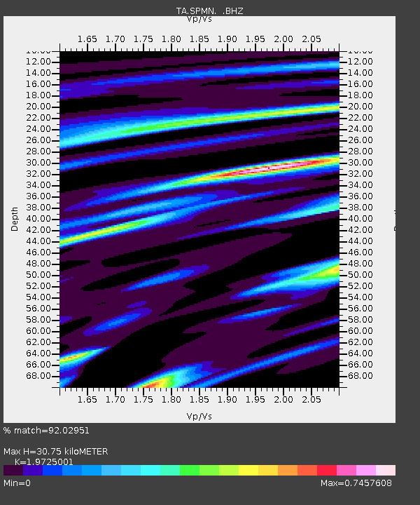
| Estimated Moho Depth: |
30.75 km |
| Estimated Crust Vp/Vs: |
1.97 |
| Assumed Crust Vp: |
6.571 km/s |
| Estimated Crust Vs: |
3.331 km/s |
| Estimated Crust Poisson's Ratio: |
0.33 |
|
| Radial Match: |
92.02951 % |
| Radial Bump: |
311 |
| Transverse Match: |
75.567154 % |
| Transverse Bump: |
400 |
| SOD ConfigId: |
626651 |
| Insert Time: |
2014-04-20 19:21:11.387 +0000 |
| GWidth: |
2.5 |
| Max Bumps: |
400 |
| Tol: |
0.001 |
|

Signal To Noise
| Channel | StoN | STA | LTA |
| TA:SPMN: :BHZ:20140218T09:34:30.950006Z | 10.242562 | 2.8116335E-6 | 2.745049E-7 |
| TA:SPMN: :BHN:20140218T09:34:30.950006Z | 4.3062015 | 9.979038E-7 | 2.3173645E-7 |
| TA:SPMN: :BHE:20140218T09:34:30.950006Z | 3.9158688 | 1.3515188E-6 | 3.4513894E-7 |
| Arrivals |
| Ps | 4.9 SECOND |
| PpPs | 13 SECOND |
| PsPs/PpSs | 18 SECOND |


