You are here: Home > Network List > TA - USArray Transportable Network (new EarthScope stations) Stations List
> Station SPMN Marine on St. Croix, MN, USA > Earthquake Result Viewer
SPMN Marine on St. Croix, MN, USA - Earthquake Result Viewer
| Earthquake location: |
Southern Alaska |
| Earthquake latitude/longitude: |
60.0/-152.2 |
| Earthquake time(UTC): |
2014/05/10 (130) 14:16:08 GMT |
| Earthquake Depth: |
96 km |
| Earthquake Magnitude: |
5.8 ML, 5.5 MI, 5.7 MWP |
| Earthquake Catalog/Contributor: |
NEIC PDE/NEIC COMCAT |
|
| Network: |
TA USArray Transportable Network (new EarthScope stations) |
| Station: |
SPMN Marine on St. Croix, MN, USA |
| Lat/Lon: |
45.22 N/92.80 W |
| Elevation: |
311 m |
|
| Distance: |
37.6 deg |
| Az: |
85.858 deg |
| Baz: |
314.842 deg |
| Ray Param: |
0.07574636 |
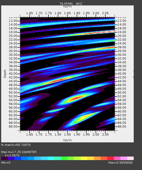
| Estimated Moho Depth: |
17.25 km |
| Estimated Crust Vp/Vs: |
2.10 |
| Assumed Crust Vp: |
6.571 km/s |
| Estimated Crust Vs: |
3.133 km/s |
| Estimated Crust Poisson's Ratio: |
0.35 |
|
| Radial Match: |
90.70978 % |
| Radial Bump: |
291 |
| Transverse Match: |
70.133224 % |
| Transverse Bump: |
400 |
| SOD ConfigId: |
626651 |
| Insert Time: |
2014-05-24 15:11:50.829 +0000 |
| GWidth: |
2.5 |
| Max Bumps: |
400 |
| Tol: |
0.001 |
|

Signal To Noise
| Channel | StoN | STA | LTA |
| TA:SPMN: :BHZ:20140510T14:22:42.625Z | 24.53883 | 1.3074296E-6 | 5.3280026E-8 |
| TA:SPMN: :BHN:20140510T14:22:42.625Z | 9.081243 | 7.4562723E-7 | 8.2106304E-8 |
| TA:SPMN: :BHE:20140510T14:22:42.625Z | 10.600665 | 7.6376E-7 | 7.204831E-8 |
| Arrivals |
| Ps | 3.1 SECOND |
| PpPs | 7.6 SECOND |
| PsPs/PpSs | 11 SECOND |


