You are here: Home > Network List > TA - USArray Transportable Network (new EarthScope stations) Stations List
> Station SPMN Marine on St. Croix, MN, USA > Earthquake Result Viewer
SPMN Marine on St. Croix, MN, USA - Earthquake Result Viewer
| Earthquake location: |
Rat Islands, Aleutian Islands |
| Earthquake latitude/longitude: |
51.8/178.8 |
| Earthquake time(UTC): |
2014/06/23 (174) 20:53:09 GMT |
| Earthquake Depth: |
108 km |
| Earthquake Magnitude: |
7.9 MWW, 7.1 MI, 7.9 MWC |
| Earthquake Catalog/Contributor: |
NEIC PDE/NEIC COMCAT |
|
| Network: |
TA USArray Transportable Network (new EarthScope stations) |
| Station: |
SPMN Marine on St. Croix, MN, USA |
| Lat/Lon: |
45.22 N/92.80 W |
| Elevation: |
311 m |
|
| Distance: |
55.5 deg |
| Az: |
59.014 deg |
| Baz: |
311.12 deg |
| Ray Param: |
0.06442916 |
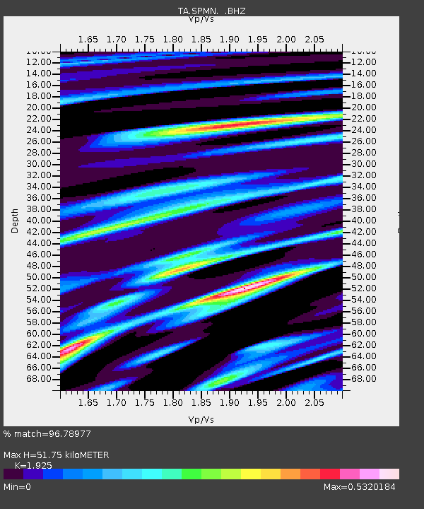
| Estimated Moho Depth: |
51.75 km |
| Estimated Crust Vp/Vs: |
1.92 |
| Assumed Crust Vp: |
6.571 km/s |
| Estimated Crust Vs: |
3.413 km/s |
| Estimated Crust Poisson's Ratio: |
0.32 |
|
| Radial Match: |
96.78977 % |
| Radial Bump: |
400 |
| Transverse Match: |
64.7203 % |
| Transverse Bump: |
400 |
| SOD ConfigId: |
739768 |
| Insert Time: |
2014-07-07 21:58:28.266 +0000 |
| GWidth: |
2.5 |
| Max Bumps: |
400 |
| Tol: |
0.001 |
|

Signal To Noise
| Channel | StoN | STA | LTA |
| TA:SPMN: :BHZ:20140623T21:02:03.12502Z | 1.765004 | 4.586945E-6 | 2.5988297E-6 |
| TA:SPMN: :BHN:20140623T21:02:03.12502Z | 1.4729384 | 3.132483E-6 | 2.1266897E-6 |
| TA:SPMN: :BHE:20140623T21:02:03.12502Z | 2.3765697 | 2.8112956E-6 | 1.1829216E-6 |
| Arrivals |
| Ps | 7.7 SECOND |
| PpPs | 22 SECOND |
| PsPs/PpSs | 30 SECOND |


