You are here: Home > Network List > TA - USArray Transportable Network (new EarthScope stations) Stations List
> Station SPMN Marine on St. Croix, MN, USA > Earthquake Result Viewer
SPMN Marine on St. Croix, MN, USA - Earthquake Result Viewer
| Earthquake location: |
Rat Islands, Aleutian Islands |
| Earthquake latitude/longitude: |
52.0/178.4 |
| Earthquake time(UTC): |
2014/06/23 (174) 21:11:41 GMT |
| Earthquake Depth: |
107 km |
| Earthquake Magnitude: |
6.0 MB |
| Earthquake Catalog/Contributor: |
NEIC PDE/NEIC COMCAT |
|
| Network: |
TA USArray Transportable Network (new EarthScope stations) |
| Station: |
SPMN Marine on St. Croix, MN, USA |
| Lat/Lon: |
45.22 N/92.80 W |
| Elevation: |
311 m |
|
| Distance: |
55.6 deg |
| Az: |
58.916 deg |
| Baz: |
311.43 deg |
| Ray Param: |
0.06436822 |
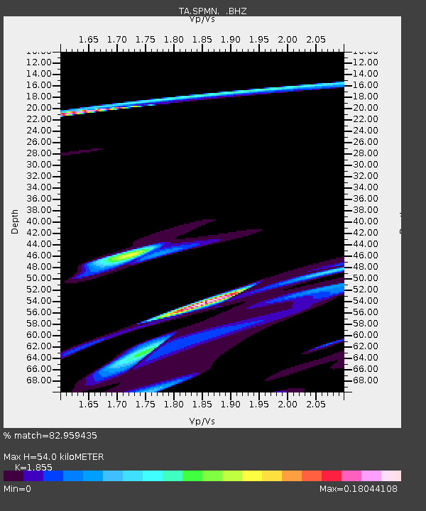
| Estimated Moho Depth: |
54.0 km |
| Estimated Crust Vp/Vs: |
1.86 |
| Assumed Crust Vp: |
6.571 km/s |
| Estimated Crust Vs: |
3.542 km/s |
| Estimated Crust Poisson's Ratio: |
0.30 |
|
| Radial Match: |
82.959435 % |
| Radial Bump: |
400 |
| Transverse Match: |
72.22787 % |
| Transverse Bump: |
351 |
| SOD ConfigId: |
739768 |
| Insert Time: |
2014-07-07 22:46:11.044 +0000 |
| GWidth: |
2.5 |
| Max Bumps: |
400 |
| Tol: |
0.001 |
|

Signal To Noise
| Channel | StoN | STA | LTA |
| TA:SPMN: :BHZ:20140623T21:20:35.024988Z | 2.713587 | 1.2491178E-4 | 4.603198E-5 |
| TA:SPMN: :BHN:20140623T21:20:35.024988Z | 0.29828998 | 3.0612064E-5 | 1.02625185E-4 |
| TA:SPMN: :BHE:20140623T21:20:35.024988Z | 0.5210876 | 4.3130112E-5 | 8.276941E-5 |
| Arrivals |
| Ps | 7.4 SECOND |
| PpPs | 22 SECOND |
| PsPs/PpSs | 30 SECOND |


