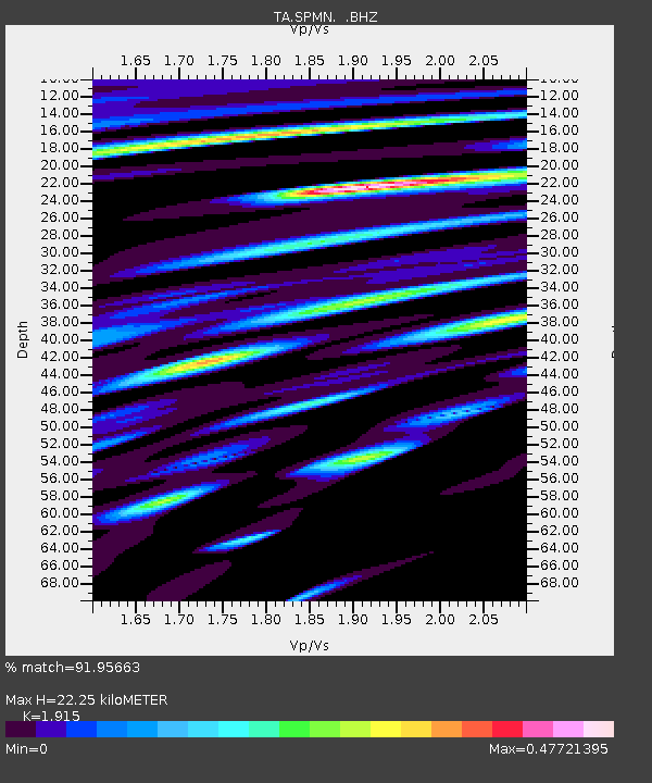
SPMN Marine on St. Croix, MN, USA - Earthquake Result Viewer

Earthquake location: Rat Islands, Aleutian Islands
Earthquake latitude/longitude: 52.3/176.7
Earthquake time(UTC): 2014/06/24 (175) 03:15:36 GMT
Earthquake Depth: 4.0 km
Earthquake Magnitude: 6.3 MWB, 5.7 ML, 6.4 MWC, 6.6 MI
Earthquake Catalog/Contributor: NEIC PDE/NEIC COMCAT
Network: TA USArray Transportable Network (new EarthScope stations)
Station: SPMN Marine on St. Croix, MN, USA
Lat/Lon: 45.22 N/92.80 W
Elevation: 311 m
Distance: 56.3 deg
Az: 58.115 deg
Baz: 312.386 deg
Ray Param: 0.064225025
Estimated Moho Depth: 22.25 km
Estimated Crust Vp/Vs: 1.91
Assumed Crust Vp: 6.571 km/s
Estimated Crust Vs: 3.431 km/s
Estimated Crust Poisson's Ratio: 0.31
Radial Match: 91.95663 %
Radial Bump: 400
Transverse Match: 74.575035 %
Transverse Bump: 400
SOD ConfigId: 739768
Insert Time: 2014-07-08 04:21:48.049 +0000
GWidth: 2.5
Max Bumps: 400
Tol: 0.001

Signal To Noise

ChannelStoNSTALTA
TA:SPMN: :BHZ:20140624T03:24:47.450005Z7.6873988.3654703E-71.0882057E-7
TA:SPMN: :BHN:20140624T03:24:47.450005Z3.7158782.916785E-77.849518E-8
TA:SPMN: :BHE:20140624T03:24:47.450005Z2.56475643.2169078E-71.2542742E-7
Arrivals
Ps3.3 SECOND
PpPs9.4 SECOND
PsPs/PpSs13 SECOND