You are here: Home > Network List > TA - USArray Transportable Network (new EarthScope stations) Stations List
> Station SPMN Marine on St. Croix, MN, USA > Earthquake Result Viewer
SPMN Marine on St. Croix, MN, USA - Earthquake Result Viewer
| Earthquake location: |
Near Coast Of Central Chile |
| Earthquake latitude/longitude: |
-36.3/-73.8 |
| Earthquake time(UTC): |
2015/06/20 (171) 02:10:06 GMT |
| Earthquake Depth: |
10 km |
| Earthquake Magnitude: |
6.4 MO |
| Earthquake Catalog/Contributor: |
NEIC PDE/NEIC ALERT |
|
| Network: |
TA USArray Transportable Network (new EarthScope stations) |
| Station: |
SPMN Marine on St. Croix, MN, USA |
| Lat/Lon: |
45.22 N/92.80 W |
| Elevation: |
311 m |
|
| Distance: |
83.0 deg |
| Az: |
346.605 deg |
| Baz: |
164.65 deg |
| Ray Param: |
0.046514977 |
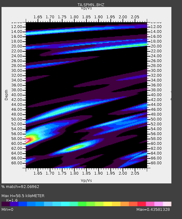
| Estimated Moho Depth: |
58.5 km |
| Estimated Crust Vp/Vs: |
1.60 |
| Assumed Crust Vp: |
6.571 km/s |
| Estimated Crust Vs: |
4.107 km/s |
| Estimated Crust Poisson's Ratio: |
0.18 |
|
| Radial Match: |
92.06962 % |
| Radial Bump: |
400 |
| Transverse Match: |
78.960236 % |
| Transverse Bump: |
400 |
| SOD ConfigId: |
7422571 |
| Insert Time: |
2019-04-19 09:51:49.099 +0000 |
| GWidth: |
2.5 |
| Max Bumps: |
400 |
| Tol: |
0.001 |
|

Signal To Noise
| Channel | StoN | STA | LTA |
| TA:SPMN: :BHZ:20150620T02:22:00.373999Z | 8.494809 | 3.5724642E-7 | 4.2054676E-8 |
| TA:SPMN: :BHN:20150620T02:22:00.373999Z | 2.374981 | 1.9610356E-7 | 8.257058E-8 |
| TA:SPMN: :BHE:20150620T02:22:00.373999Z | 1.0025333 | 6.65731E-8 | 6.640487E-8 |
| Arrivals |
| Ps | 5.5 SECOND |
| PpPs | 22 SECOND |
| PsPs/PpSs | 28 SECOND |


