You are here: Home > Network List > TA - USArray Transportable Network (new EarthScope stations) Stations List
> Station SPMN Marine on St. Croix, MN, USA > Earthquake Result Viewer
SPMN Marine on St. Croix, MN, USA - Earthquake Result Viewer
| Earthquake location: |
Fox Islands, Aleutian Islands |
| Earthquake latitude/longitude: |
52.4/-169.7 |
| Earthquake time(UTC): |
2015/07/27 (208) 04:49:44 GMT |
| Earthquake Depth: |
12 km |
| Earthquake Magnitude: |
6.9 MO |
| Earthquake Catalog/Contributor: |
NEIC PDE/NEIC ALERT |
|
| Network: |
TA USArray Transportable Network (new EarthScope stations) |
| Station: |
SPMN Marine on St. Croix, MN, USA |
| Lat/Lon: |
45.22 N/92.80 W |
| Elevation: |
311 m |
|
| Distance: |
48.9 deg |
| Az: |
65.976 deg |
| Baz: |
307.597 deg |
| Ray Param: |
0.06905421 |
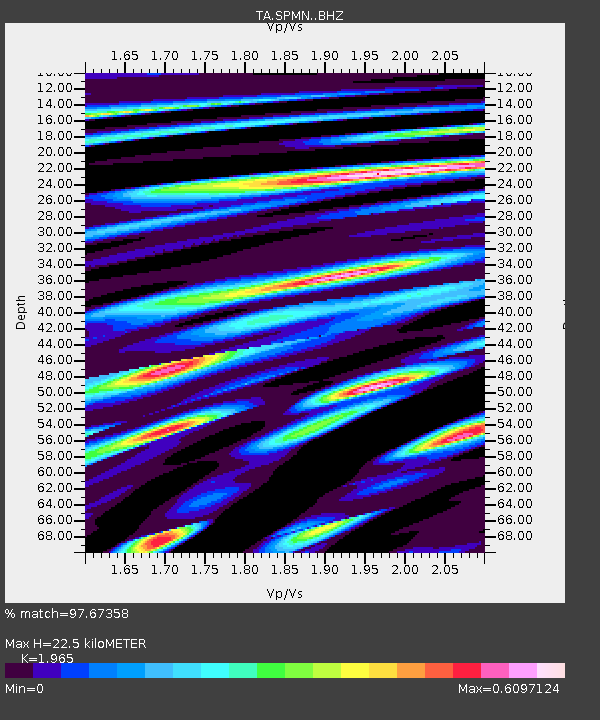
| Estimated Moho Depth: |
22.5 km |
| Estimated Crust Vp/Vs: |
1.97 |
| Assumed Crust Vp: |
6.571 km/s |
| Estimated Crust Vs: |
3.344 km/s |
| Estimated Crust Poisson's Ratio: |
0.33 |
|
| Radial Match: |
97.67358 % |
| Radial Bump: |
354 |
| Transverse Match: |
87.27775 % |
| Transverse Bump: |
400 |
| SOD ConfigId: |
7422571 |
| Insert Time: |
2019-04-19 23:37:06.386 +0000 |
| GWidth: |
2.5 |
| Max Bumps: |
400 |
| Tol: |
0.001 |
|

Signal To Noise
| Channel | StoN | STA | LTA |
| TA:SPMN: :BHZ:20150727T04:57:58.024988Z | 41.494003 | 2.0365198E-6 | 4.907986E-8 |
| TA:SPMN: :BHN:20150727T04:57:58.024988Z | 16.287186 | 7.170843E-7 | 4.4027512E-8 |
| TA:SPMN: :BHE:20150727T04:57:58.024988Z | 17.053299 | 9.57292E-7 | 5.6135292E-8 |
| Arrivals |
| Ps | 3.5 SECOND |
| PpPs | 9.6 SECOND |
| PsPs/PpSs | 13 SECOND |


