You are here: Home > Network List > TA - USArray Transportable Network (new EarthScope stations) Stations List
> Station SPMN Marine on St. Croix, MN, USA > Earthquake Result Viewer
SPMN Marine on St. Croix, MN, USA - Earthquake Result Viewer
| Earthquake location: |
Near Coast Of Chiapas, Mexico |
| Earthquake latitude/longitude: |
14.9/-94.0 |
| Earthquake time(UTC): |
2015/05/10 (130) 00:50:18 GMT |
| Earthquake Depth: |
6.7 km |
| Earthquake Magnitude: |
5.6 MB |
| Earthquake Catalog/Contributor: |
NEIC PDE/NEIC COMCAT |
|
| Network: |
TA USArray Transportable Network (new EarthScope stations) |
| Station: |
SPMN Marine on St. Croix, MN, USA |
| Lat/Lon: |
45.22 N/92.80 W |
| Elevation: |
311 m |
|
| Distance: |
30.3 deg |
| Az: |
1.663 deg |
| Baz: |
182.276 deg |
| Ray Param: |
0.079378136 |
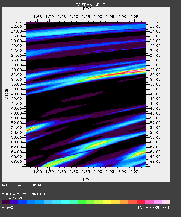
| Estimated Moho Depth: |
29.75 km |
| Estimated Crust Vp/Vs: |
2.09 |
| Assumed Crust Vp: |
6.571 km/s |
| Estimated Crust Vs: |
3.14 km/s |
| Estimated Crust Poisson's Ratio: |
0.35 |
|
| Radial Match: |
81.088684 % |
| Radial Bump: |
400 |
| Transverse Match: |
59.521027 % |
| Transverse Bump: |
400 |
| SOD ConfigId: |
976571 |
| Insert Time: |
2015-05-24 01:32:10.473 +0000 |
| GWidth: |
2.5 |
| Max Bumps: |
400 |
| Tol: |
0.001 |
|

Signal To Noise
| Channel | StoN | STA | LTA |
| TA:SPMN: :BHZ:20150510T00:55:59.224995Z | 6.1082635 | 6.928346E-7 | 1.13425784E-7 |
| TA:SPMN: :BHN:20150510T00:55:59.224995Z | 4.053691 | 6.131607E-7 | 1.5125985E-7 |
| TA:SPMN: :BHE:20150510T00:55:59.224995Z | 1.3337836 | 1.800521E-7 | 1.3499348E-7 |
| Arrivals |
| Ps | 5.3 SECOND |
| PpPs | 13 SECOND |
| PsPs/PpSs | 18 SECOND |


