You are here: Home > Network List > XD14 - Illuminating the architecture of the greater Mount St. Helens magmatic systems f Stations List
> Station MK07 "Mount St Helens, WA" > Earthquake Result Viewer
MK07 "Mount St Helens, WA" - Earthquake Result Viewer
| Earthquake location: |
Near Coast Of Chiapas, Mexico |
| Earthquake latitude/longitude: |
15.9/-93.4 |
| Earthquake time(UTC): |
2015/12/17 (351) 19:49:54 GMT |
| Earthquake Depth: |
97 km |
| Earthquake Magnitude: |
6.4 MWB, 6.6 MI |
| Earthquake Catalog/Contributor: |
NEIC PDE/NEIC COMCAT |
|
| Network: |
XD Illuminating the architecture of the greater Mount St. Helens magmatic systems f |
| Station: |
MK07 "Mount St Helens, WA" |
| Lat/Lon: |
46.15 N/122.12 W |
| Elevation: |
929 m |
|
| Distance: |
38.5 deg |
| Az: |
327.598 deg |
| Baz: |
132.119 deg |
| Ray Param: |
0.0751963 |
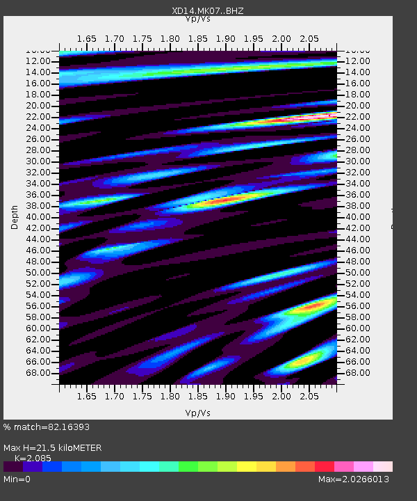
| Estimated Moho Depth: |
21.5 km |
| Estimated Crust Vp/Vs: |
2.09 |
| Assumed Crust Vp: |
6.566 km/s |
| Estimated Crust Vs: |
3.149 km/s |
| Estimated Crust Poisson's Ratio: |
0.35 |
|
| Radial Match: |
82.16393 % |
| Radial Bump: |
400 |
| Transverse Match: |
64.757065 % |
| Transverse Bump: |
400 |
| SOD ConfigId: |
7422571 |
| Insert Time: |
2019-04-21 14:44:13.190 +0000 |
| GWidth: |
2.5 |
| Max Bumps: |
400 |
| Tol: |
0.001 |
|

Signal To Noise
| Channel | StoN | STA | LTA |
| XD:MK07: :BHZ:20151217T19:56:36.555009Z | 4.546738 | 2.213198E-6 | 4.867661E-7 |
| XD:MK07: :BHN:20151217T19:56:36.555009Z | 2.4470456 | 1.2385025E-6 | 5.061215E-7 |
| XD:MK07: :BHE:20151217T19:56:36.555009Z | 4.490626 | 1.4154759E-6 | 3.1520685E-7 |
| Arrivals |
| Ps | 3.8 SECOND |
| PpPs | 9.5 SECOND |
| PsPs/PpSs | 13 SECOND |


