You are here: Home > Network List > XD14 - Illuminating the architecture of the greater Mount St. Helens magmatic systems f Stations List
> Station MK07 "Mount St Helens, WA" > Earthquake Result Viewer
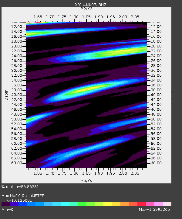
MK07 "Mount St Helens, WA" - Earthquake Result Viewer
| Earthquake location: |
Off Coast Of Jalisco, Mexico |
| Earthquake latitude/longitude: |
18.8/-107.0 |
| Earthquake time(UTC): |
2016/01/21 (021) 18:06:59 GMT |
| Earthquake Depth: |
10 km |
| Earthquake Magnitude: |
6.6 MWW, 6.9 MI |
| Earthquake Catalog/Contributor: |
NEIC PDE/NEIC COMCAT |
|
| Network: |
XD Illuminating the architecture of the greater Mount St. Helens magmatic systems f |
| Station: |
MK07 "Mount St Helens, WA" |
| Lat/Lon: |
46.15 N/122.12 W |
| Elevation: |
929 m |
|
| Distance: |
30.0 deg |
| Az: |
338.661 deg |
| Baz: |
150.28 deg |
| Ray Param: |
0.07945256 |
| Estimated Moho Depth: |
10.0 km |
| Estimated Crust Vp/Vs: |
1.61 |
| Assumed Crust Vp: |
6.566 km/s |
| Estimated Crust Vs: |
4.072 km/s |
| Estimated Crust Poisson's Ratio: |
0.19 |
|
| Radial Match: |
85.85381 % |
| Radial Bump: |
400 |
| Transverse Match: |
52.819153 % |
| Transverse Bump: |
400 |
| SOD ConfigId: |
7422571 |
| Insert Time: |
2019-04-21 19:18:05.500 +0000 |
| GWidth: |
2.5 |
| Max Bumps: |
400 |
| Tol: |
0.001 |
|

Signal To Noise
| Channel | StoN | STA | LTA |
| XD:MK07: :BHZ:20160121T18:12:35.735006Z | 4.4485526 | 1.9452316E-6 | 4.372729E-7 |
| XD:MK07: :BHN:20160121T18:12:35.735006Z | 2.275085 | 1.3636419E-6 | 5.993806E-7 |
| XD:MK07: :BHE:20160121T18:12:35.735006Z | 1.4876361 | 1.0738462E-6 | 7.2184736E-7 |
| Arrivals |
| Ps | 1.0 SECOND |
| PpPs | 3.6 SECOND |
| PsPs/PpSs | 4.6 SECOND |


