You are here: Home > Network List > XD14 - Illuminating the architecture of the greater Mount St. Helens magmatic systems f Stations List
> Station MK07 "Mount St Helens, WA" > Earthquake Result Viewer
MK07 "Mount St Helens, WA" - Earthquake Result Viewer
| Earthquake location: |
Vanuatu Islands |
| Earthquake latitude/longitude: |
-14.4/166.8 |
| Earthquake time(UTC): |
2016/04/03 (094) 08:23:53 GMT |
| Earthquake Depth: |
35 km |
| Earthquake Magnitude: |
6.9 MWW, 7.2 MI |
| Earthquake Catalog/Contributor: |
NEIC PDE/NEIC COMCAT |
|
| Network: |
XD Illuminating the architecture of the greater Mount St. Helens magmatic systems f |
| Station: |
MK07 "Mount St Helens, WA" |
| Lat/Lon: |
46.15 N/122.12 W |
| Elevation: |
929 m |
|
| Distance: |
87.6 deg |
| Az: |
41.155 deg |
| Baz: |
246.567 deg |
| Ray Param: |
0.04315006 |
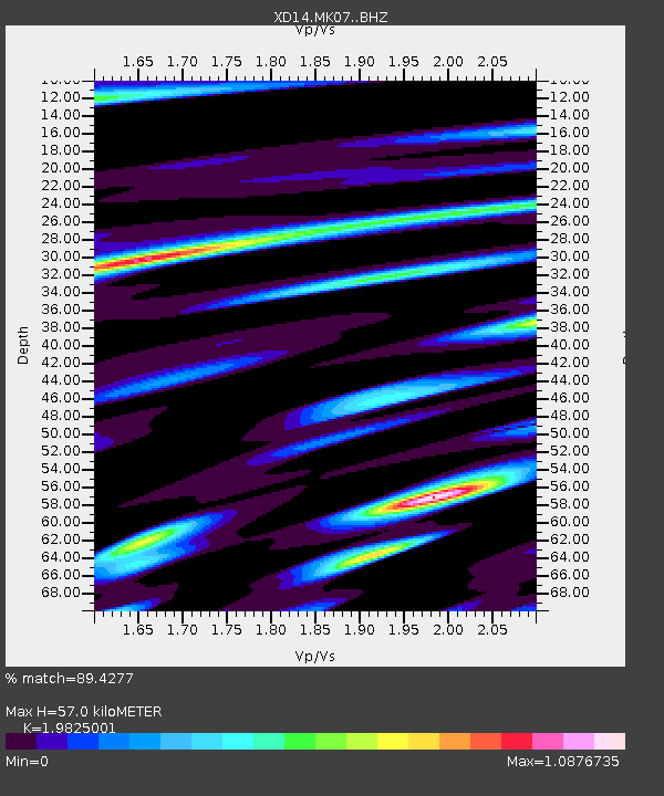
| Estimated Moho Depth: |
57.0 km |
| Estimated Crust Vp/Vs: |
1.98 |
| Assumed Crust Vp: |
6.566 km/s |
| Estimated Crust Vs: |
3.312 km/s |
| Estimated Crust Poisson's Ratio: |
0.33 |
|
| Radial Match: |
89.4277 % |
| Radial Bump: |
400 |
| Transverse Match: |
78.93279 % |
| Transverse Bump: |
400 |
| SOD ConfigId: |
7422571 |
| Insert Time: |
2019-04-22 03:36:49.755 +0000 |
| GWidth: |
2.5 |
| Max Bumps: |
400 |
| Tol: |
0.001 |
|

Signal To Noise
| Channel | StoN | STA | LTA |
| XD:MK07: :BHZ:20160403T08:36:06.594983Z | 22.276258 | 2.7914077E-6 | 1.2530865E-7 |
| XD:MK07: :BHN:20160403T08:36:06.594983Z | 3.3429387 | 5.6708194E-7 | 1.6963577E-7 |
| XD:MK07: :BHE:20160403T08:36:06.594983Z | 4.674881 | 9.229696E-7 | 1.9743167E-7 |
| Arrivals |
| Ps | 8.7 SECOND |
| PpPs | 25 SECOND |
| PsPs/PpSs | 34 SECOND |


