You are here: Home > Network List > XD14 - Illuminating the architecture of the greater Mount St. Helens magmatic systems f Stations List
> Station MK07 "Mount St Helens, WA" > Earthquake Result Viewer
MK07 "Mount St Helens, WA" - Earthquake Result Viewer
| Earthquake location: |
Kermadec Islands Region |
| Earthquake latitude/longitude: |
-28.0/-176.4 |
| Earthquake time(UTC): |
2016/07/13 (195) 12:11:13 GMT |
| Earthquake Depth: |
12 km |
| Earthquake Magnitude: |
6.3 MWB |
| Earthquake Catalog/Contributor: |
NEIC PDE/NEIC COMCAT |
|
| Network: |
XD Illuminating the architecture of the greater Mount St. Helens magmatic systems f |
| Station: |
MK07 "Mount St Helens, WA" |
| Lat/Lon: |
46.15 N/122.12 W |
| Elevation: |
929 m |
|
| Distance: |
88.7 deg |
| Az: |
34.364 deg |
| Baz: |
225.871 deg |
| Ray Param: |
0.04239097 |
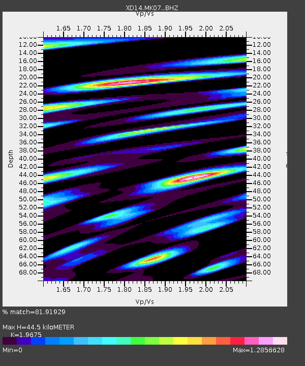
| Estimated Moho Depth: |
44.5 km |
| Estimated Crust Vp/Vs: |
1.97 |
| Assumed Crust Vp: |
6.566 km/s |
| Estimated Crust Vs: |
3.337 km/s |
| Estimated Crust Poisson's Ratio: |
0.33 |
|
| Radial Match: |
81.91929 % |
| Radial Bump: |
400 |
| Transverse Match: |
80.6681 % |
| Transverse Bump: |
400 |
| SOD ConfigId: |
11737051 |
| Insert Time: |
2019-04-25 02:09:25.524 +0000 |
| GWidth: |
2.5 |
| Max Bumps: |
400 |
| Tol: |
0.001 |
|

Signal To Noise
| Channel | StoN | STA | LTA |
| XD:MK07: :BHZ:20160713T12:23:34.475012Z | 2.9963737 | 5.725443E-7 | 1.910791E-7 |
| XD:MK07: :BHN:20160713T12:23:34.475012Z | 2.2187502 | 3.3559087E-7 | 1.5125221E-7 |
| XD:MK07: :BHE:20160713T12:23:34.475012Z | 1.3280603 | 2.1658174E-7 | 1.6308127E-7 |
| Arrivals |
| Ps | 6.7 SECOND |
| PpPs | 20 SECOND |
| PsPs/PpSs | 26 SECOND |


