You are here: Home > Network List > XD14 - Illuminating the architecture of the greater Mount St. Helens magmatic systems f Stations List
> Station MK07 "Mount St Helens, WA" > Earthquake Result Viewer
MK07 "Mount St Helens, WA" - Earthquake Result Viewer
| Earthquake location: |
Vanuatu Islands |
| Earthquake latitude/longitude: |
-16.4/168.1 |
| Earthquake time(UTC): |
2015/02/19 (050) 13:18:32 GMT |
| Earthquake Depth: |
10 km |
| Earthquake Magnitude: |
6.5 MWP |
| Earthquake Catalog/Contributor: |
NEIC PDE/NEIC COMCAT |
|
| Network: |
XD Illuminating the architecture of the greater Mount St. Helens magmatic systems f |
| Station: |
MK07 "Mount St Helens, WA" |
| Lat/Lon: |
46.15 N/122.12 W |
| Elevation: |
929 m |
|
| Distance: |
88.4 deg |
| Az: |
40.741 deg |
| Baz: |
244.307 deg |
| Ray Param: |
0.042649355 |
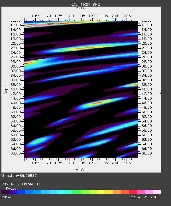
| Estimated Moho Depth: |
12.0 km |
| Estimated Crust Vp/Vs: |
1.60 |
| Assumed Crust Vp: |
6.566 km/s |
| Estimated Crust Vs: |
4.104 km/s |
| Estimated Crust Poisson's Ratio: |
0.18 |
|
| Radial Match: |
86.56987 % |
| Radial Bump: |
400 |
| Transverse Match: |
81.92423 % |
| Transverse Bump: |
400 |
| SOD ConfigId: |
7019011 |
| Insert Time: |
2019-04-16 22:54:23.234 +0000 |
| GWidth: |
2.5 |
| Max Bumps: |
400 |
| Tol: |
0.001 |
|

Signal To Noise
| Channel | StoN | STA | LTA |
| XD:MK07: :BHZ:20150219T13:30:52.68502Z | 4.8515515 | 1.6432053E-6 | 3.3869688E-7 |
| XD:MK07: :BHN:20150219T13:30:52.68502Z | 1.6131198 | 7.0228555E-7 | 4.3535857E-7 |
| XD:MK07: :BHE:20150219T13:30:52.68502Z | 1.7596822 | 4.0526248E-7 | 2.3030438E-7 |
| Arrivals |
| Ps | 1.1 SECOND |
| PpPs | 4.6 SECOND |
| PsPs/PpSs | 5.8 SECOND |


