You are here: Home > Network List > XD14 - Illuminating the architecture of the greater Mount St. Helens magmatic systems f Stations List
> Station MK07 "Mount St Helens, WA" > Earthquake Result Viewer
MK07 "Mount St Helens, WA" - Earthquake Result Viewer
| Earthquake location: |
New Britain Region, P.N.G. |
| Earthquake latitude/longitude: |
-5.5/151.9 |
| Earthquake time(UTC): |
2015/05/05 (125) 01:44:07 GMT |
| Earthquake Depth: |
63 km |
| Earthquake Magnitude: |
7.4 MWW, 7.5 MI |
| Earthquake Catalog/Contributor: |
NEIC PDE/NEIC COMCAT |
|
| Network: |
XD Illuminating the architecture of the greater Mount St. Helens magmatic systems f |
| Station: |
MK07 "Mount St Helens, WA" |
| Lat/Lon: |
46.15 N/122.12 W |
| Elevation: |
929 m |
|
| Distance: |
91.1 deg |
| Az: |
43.913 deg |
| Baz: |
263.306 deg |
| Ray Param: |
0.041612737 |
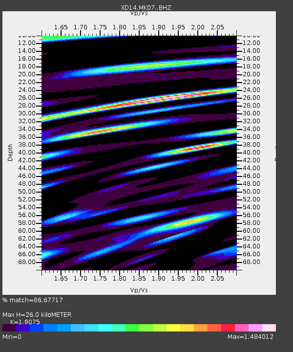
| Estimated Moho Depth: |
26.0 km |
| Estimated Crust Vp/Vs: |
1.91 |
| Assumed Crust Vp: |
6.566 km/s |
| Estimated Crust Vs: |
3.442 km/s |
| Estimated Crust Poisson's Ratio: |
0.31 |
|
| Radial Match: |
86.67717 % |
| Radial Bump: |
400 |
| Transverse Match: |
77.62952 % |
| Transverse Bump: |
400 |
| SOD ConfigId: |
7422571 |
| Insert Time: |
2019-04-18 16:04:45.576 +0000 |
| GWidth: |
2.5 |
| Max Bumps: |
400 |
| Tol: |
0.001 |
|

Signal To Noise
| Channel | StoN | STA | LTA |
| XD:MK07: :BHZ:20150505T01:56:34.945015Z | 3.8918881 | 7.2562665E-7 | 1.8644592E-7 |
| XD:MK07: :BHN:20150505T01:56:34.945015Z | 2.087572 | 3.7496383E-7 | 1.7961719E-7 |
| XD:MK07: :BHE:20150505T01:56:34.945015Z | 2.0671391 | 3.2401672E-7 | 1.5674645E-7 |
| Arrivals |
| Ps | 3.7 SECOND |
| PpPs | 11 SECOND |
| PsPs/PpSs | 15 SECOND |


