You are here: Home > Network List > UW - Pacific Northwest Regional Seismic Network Stations List
> Station ABER Abernathy Mountain, Cowlitz County, WA, USA > Earthquake Result Viewer
ABER Abernathy Mountain, Cowlitz County, WA, USA - Earthquake Result Viewer
| Earthquake location: |
Southeast Of Loyalty Islands |
| Earthquake latitude/longitude: |
-21.2/170.1 |
| Earthquake time(UTC): |
2022/09/14 (257) 11:04:07 GMT |
| Earthquake Depth: |
124 km |
| Earthquake Magnitude: |
7.0 Mi |
| Earthquake Catalog/Contributor: |
NEIC PDE/at |
|
| Network: |
UW Pacific Northwest Regional Seismic Network |
| Station: |
ABER Abernathy Mountain, Cowlitz County, WA, USA |
| Lat/Lon: |
46.34 N/123.10 W |
| Elevation: |
786 m |
|
| Distance: |
90.3 deg |
| Az: |
39.55 deg |
| Baz: |
239.059 deg |
| Ray Param: |
0.041690912 |
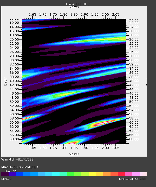
| Estimated Moho Depth: |
60.0 km |
| Estimated Crust Vp/Vs: |
1.99 |
| Assumed Crust Vp: |
6.566 km/s |
| Estimated Crust Vs: |
3.3 km/s |
| Estimated Crust Poisson's Ratio: |
0.33 |
|
| Radial Match: |
81.71582 % |
| Radial Bump: |
400 |
| Transverse Match: |
81.42653 % |
| Transverse Bump: |
400 |
| SOD ConfigId: |
28764291 |
| Insert Time: |
2022-09-28 11:37:22.916 +0000 |
| GWidth: |
2.5 |
| Max Bumps: |
400 |
| Tol: |
0.001 |
|

Signal To Noise
| Channel | StoN | STA | LTA |
| UW:ABER: :HHZ:20220914T11:16:22.48999Z | 49.73865 | 3.3690212E-6 | 6.773447E-8 |
| UW:ABER: :HHN:20220914T11:16:22.48999Z | 12.059518 | 1.5492753E-6 | 1.284691E-7 |
| UW:ABER: :HHE:20220914T11:16:22.48999Z | 12.191831 | 1.7179756E-6 | 1.4091204E-7 |
| Arrivals |
| Ps | 9.2 SECOND |
| PpPs | 27 SECOND |
| PsPs/PpSs | 36 SECOND |


