You are here: Home > Network List > UW - Pacific Northwest Regional Seismic Network Stations List
> Station ABER Abernathy Mountain, Cowlitz County, WA, USA > Earthquake Result Viewer
ABER Abernathy Mountain, Cowlitz County, WA, USA - Earthquake Result Viewer
| Earthquake location: |
Taiwan |
| Earthquake latitude/longitude: |
23.1/121.3 |
| Earthquake time(UTC): |
2022/09/18 (261) 06:44:15 GMT |
| Earthquake Depth: |
10 km |
| Earthquake Magnitude: |
7.2 Mi |
| Earthquake Catalog/Contributor: |
NEIC PDE/at |
|
| Network: |
UW Pacific Northwest Regional Seismic Network |
| Station: |
ABER Abernathy Mountain, Cowlitz County, WA, USA |
| Lat/Lon: |
46.34 N/123.10 W |
| Elevation: |
786 m |
|
| Distance: |
89.7 deg |
| Az: |
38.665 deg |
| Baz: |
303.862 deg |
| Ray Param: |
0.041732997 |
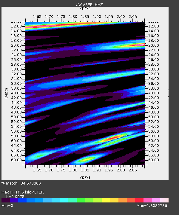
| Estimated Moho Depth: |
19.5 km |
| Estimated Crust Vp/Vs: |
2.10 |
| Assumed Crust Vp: |
6.566 km/s |
| Estimated Crust Vs: |
3.13 km/s |
| Estimated Crust Poisson's Ratio: |
0.35 |
|
| Radial Match: |
84.573006 % |
| Radial Bump: |
400 |
| Transverse Match: |
86.42481 % |
| Transverse Bump: |
366 |
| SOD ConfigId: |
28764291 |
| Insert Time: |
2022-10-02 07:12:18.334 +0000 |
| GWidth: |
2.5 |
| Max Bumps: |
400 |
| Tol: |
0.001 |
|

Signal To Noise
| Channel | StoN | STA | LTA |
| UW:ABER: :HHZ:20220918T06:56:41.500Z | 4.905986 | 9.909211E-7 | 2.0198203E-7 |
| UW:ABER: :HHN:20220918T06:56:41.500Z | 1.2292372 | 4.5191467E-7 | 3.676383E-7 |
| UW:ABER: :HHE:20220918T06:56:41.500Z | 0.8954337 | 3.5060296E-7 | 3.915454E-7 |
| Arrivals |
| Ps | 3.3 SECOND |
| PpPs | 9.0 SECOND |
| PsPs/PpSs | 12 SECOND |


