You are here: Home > Network List > UW - Pacific Northwest Regional Seismic Network Stations List
> Station ABER Abernathy Mountain, Cowlitz County, WA, USA > Earthquake Result Viewer
ABER Abernathy Mountain, Cowlitz County, WA, USA - Earthquake Result Viewer
| Earthquake location: |
Solomon Islands |
| Earthquake latitude/longitude: |
-9.8/159.6 |
| Earthquake time(UTC): |
2022/11/22 (326) 02:03:07 GMT |
| Earthquake Depth: |
14 km |
| Earthquake Magnitude: |
7.0 Mww |
| Earthquake Catalog/Contributor: |
NEIC PDE/us |
|
| Network: |
UW Pacific Northwest Regional Seismic Network |
| Station: |
ABER Abernathy Mountain, Cowlitz County, WA, USA |
| Lat/Lon: |
46.34 N/123.10 W |
| Elevation: |
786 m |
|
| Distance: |
88.4 deg |
| Az: |
42.541 deg |
| Baz: |
254.129 deg |
| Ray Param: |
0.042606484 |
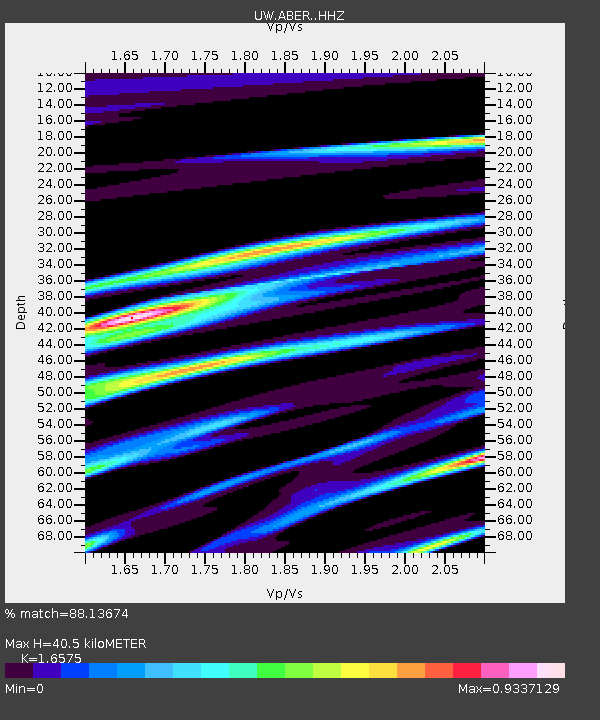
| Estimated Moho Depth: |
40.5 km |
| Estimated Crust Vp/Vs: |
1.66 |
| Assumed Crust Vp: |
6.566 km/s |
| Estimated Crust Vs: |
3.961 km/s |
| Estimated Crust Poisson's Ratio: |
0.21 |
|
| Radial Match: |
88.13674 % |
| Radial Bump: |
400 |
| Transverse Match: |
84.42345 % |
| Transverse Bump: |
360 |
| SOD ConfigId: |
29823551 |
| Insert Time: |
2022-12-06 02:33:31.953 +0000 |
| GWidth: |
2.5 |
| Max Bumps: |
400 |
| Tol: |
0.001 |
|

Signal To Noise
| Channel | StoN | STA | LTA |
| UW:ABER: :HHZ:20221122T02:15:26.929973Z | 9.723971 | 2.182616E-6 | 2.2445727E-7 |
| UW:ABER: :HHN:20221122T02:15:26.929973Z | 1.8655993 | 7.287294E-7 | 3.906141E-7 |
| UW:ABER: :HHE:20221122T02:15:26.929973Z | 2.20994 | 1.23869E-6 | 5.605084E-7 |
| Arrivals |
| Ps | 4.2 SECOND |
| PpPs | 16 SECOND |
| PsPs/PpSs | 20 SECOND |


