You are here: Home > Network List > UW - Pacific Northwest Regional Seismic Network Stations List
> Station ABER Abernathy Mountain, Cowlitz County, WA, USA > Earthquake Result Viewer
ABER Abernathy Mountain, Cowlitz County, WA, USA - Earthquake Result Viewer
| Earthquake location: |
Southeast Of Loyalty Islands |
| Earthquake latitude/longitude: |
-23.1/170.4 |
| Earthquake time(UTC): |
2023/05/20 (140) 01:51:01 GMT |
| Earthquake Depth: |
45 km |
| Earthquake Magnitude: |
7.4 Mi |
| Earthquake Catalog/Contributor: |
NEIC PDE/at |
|
| Network: |
UW Pacific Northwest Regional Seismic Network |
| Station: |
ABER Abernathy Mountain, Cowlitz County, WA, USA |
| Lat/Lon: |
46.34 N/123.10 W |
| Elevation: |
786 m |
|
| Distance: |
91.5 deg |
| Az: |
39.46 deg |
| Baz: |
237.641 deg |
| Ray Param: |
0.041581243 |
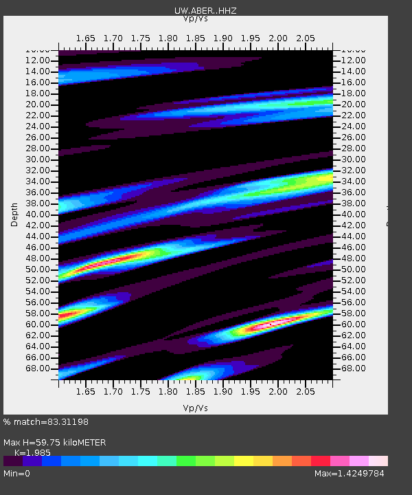
| Estimated Moho Depth: |
59.75 km |
| Estimated Crust Vp/Vs: |
1.99 |
| Assumed Crust Vp: |
6.566 km/s |
| Estimated Crust Vs: |
3.308 km/s |
| Estimated Crust Poisson's Ratio: |
0.33 |
|
| Radial Match: |
83.31198 % |
| Radial Bump: |
400 |
| Transverse Match: |
82.51543 % |
| Transverse Bump: |
400 |
| SOD ConfigId: |
30536071 |
| Insert Time: |
2023-06-03 02:17:42.095 +0000 |
| GWidth: |
2.5 |
| Max Bumps: |
400 |
| Tol: |
0.001 |
|

Signal To Noise
| Channel | StoN | STA | LTA |
| UW:ABER: :HHZ:20230520T02:03:31.619995Z | 4.7853227 | 1.0126187E-6 | 2.1160928E-7 |
| UW:ABER: :HHN:20230520T02:03:31.619995Z | 0.80764824 | 2.2027758E-7 | 2.727395E-7 |
| UW:ABER: :HHE:20230520T02:03:31.619995Z | 0.74651635 | 2.5470047E-7 | 3.411854E-7 |
| Arrivals |
| Ps | 9.1 SECOND |
| PpPs | 27 SECOND |
| PsPs/PpSs | 36 SECOND |


