You are here: Home > Network List > UW - Pacific Northwest Regional Seismic Network Stations List
> Station ABER Abernathy Mountain, Cowlitz County, WA, USA > Earthquake Result Viewer
ABER Abernathy Mountain, Cowlitz County, WA, USA - Earthquake Result Viewer
| Earthquake location: |
South Of Fiji Islands |
| Earthquake latitude/longitude: |
-23.0/-177.2 |
| Earthquake time(UTC): |
2023/06/15 (166) 18:06:27 GMT |
| Earthquake Depth: |
167 km |
| Earthquake Magnitude: |
7.2 Mww |
| Earthquake Catalog/Contributor: |
NEIC PDE/us |
|
| Network: |
UW Pacific Northwest Regional Seismic Network |
| Station: |
ABER Abernathy Mountain, Cowlitz County, WA, USA |
| Lat/Lon: |
46.34 N/123.10 W |
| Elevation: |
786 m |
|
| Distance: |
84.6 deg |
| Az: |
34.315 deg |
| Baz: |
228.584 deg |
| Ray Param: |
0.044985674 |
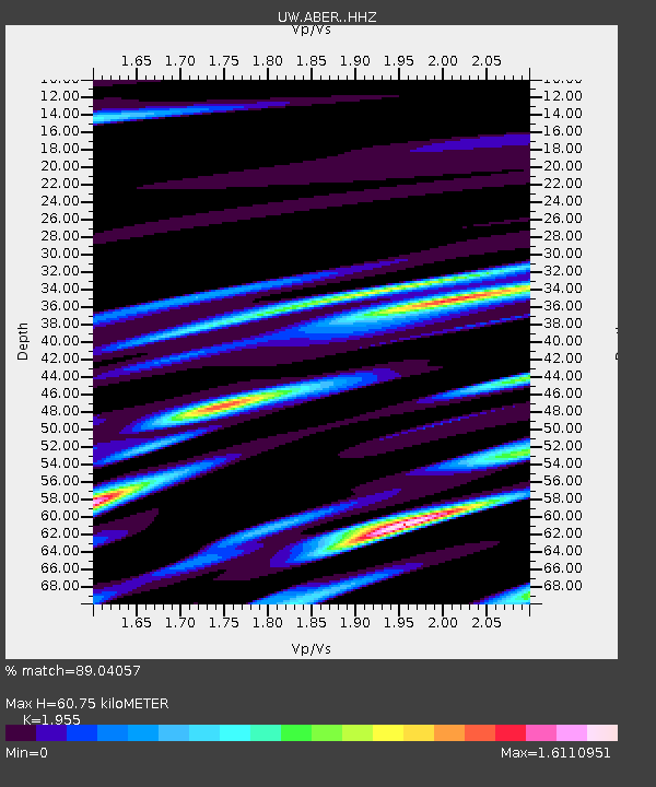
| Estimated Moho Depth: |
60.75 km |
| Estimated Crust Vp/Vs: |
1.96 |
| Assumed Crust Vp: |
6.566 km/s |
| Estimated Crust Vs: |
3.359 km/s |
| Estimated Crust Poisson's Ratio: |
0.32 |
|
| Radial Match: |
89.04057 % |
| Radial Bump: |
400 |
| Transverse Match: |
56.81003 % |
| Transverse Bump: |
294 |
| SOD ConfigId: |
30536071 |
| Insert Time: |
2023-06-29 19:10:03.089 +0000 |
| GWidth: |
2.5 |
| Max Bumps: |
400 |
| Tol: |
0.001 |
|

Signal To Noise
| Channel | StoN | STA | LTA |
| UW:ABER: :HHZ:20230615T18:18:11.100021Z | 22.179483 | 4.2717083E-6 | 1.9259728E-7 |
| UW:ABER: :HHN:20230615T18:18:11.100021Z | 3.8396256 | 2.0108355E-6 | 5.2370615E-7 |
| UW:ABER: :HHE:20230615T18:18:11.100021Z | 4.3233128 | 1.9552488E-6 | 4.522571E-7 |
| Arrivals |
| Ps | 9.0 SECOND |
| PpPs | 27 SECOND |
| PsPs/PpSs | 36 SECOND |


