You are here: Home > Network List > UW - Pacific Northwest Regional Seismic Network Stations List
> Station ABER Abernathy Mountain, Cowlitz County, WA, USA > Earthquake Result Viewer
ABER Abernathy Mountain, Cowlitz County, WA, USA - Earthquake Result Viewer
| Earthquake location: |
Vanuatu Islands |
| Earthquake latitude/longitude: |
-14.8/167.9 |
| Earthquake time(UTC): |
2023/07/26 (207) 12:44:35 GMT |
| Earthquake Depth: |
13 km |
| Earthquake Magnitude: |
6.4 mww |
| Earthquake Catalog/Contributor: |
NEIC PDE/us |
|
| Network: |
UW Pacific Northwest Regional Seismic Network |
| Station: |
ABER Abernathy Mountain, Cowlitz County, WA, USA |
| Lat/Lon: |
46.34 N/123.10 W |
| Elevation: |
786 m |
|
| Distance: |
86.7 deg |
| Az: |
40.373 deg |
| Baz: |
244.767 deg |
| Ray Param: |
0.043871198 |
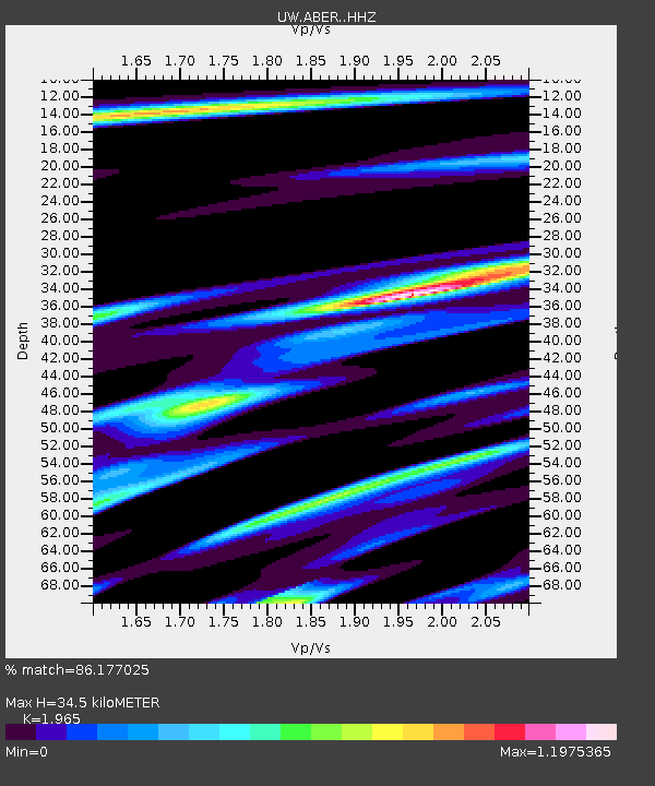
| Estimated Moho Depth: |
34.5 km |
| Estimated Crust Vp/Vs: |
1.97 |
| Assumed Crust Vp: |
6.566 km/s |
| Estimated Crust Vs: |
3.342 km/s |
| Estimated Crust Poisson's Ratio: |
0.33 |
|
| Radial Match: |
86.177025 % |
| Radial Bump: |
400 |
| Transverse Match: |
80.45472 % |
| Transverse Bump: |
400 |
| SOD ConfigId: |
31937991 |
| Insert Time: |
2023-08-09 13:14:17.185 +0000 |
| GWidth: |
2.5 |
| Max Bumps: |
400 |
| Tol: |
0.001 |
|

Signal To Noise
| Channel | StoN | STA | LTA |
| UW:ABER: :HHZ:20230726T12:56:47.460011Z | 8.432908 | 9.612783E-7 | 1.1399132E-7 |
| UW:ABER: :HHN:20230726T12:56:47.460011Z | 1.2966202 | 3.0569421E-7 | 2.3576233E-7 |
| UW:ABER: :HHE:20230726T12:56:47.460011Z | 3.0203307 | 5.6863246E-7 | 1.8826829E-7 |
| Arrivals |
| Ps | 5.2 SECOND |
| PpPs | 15 SECOND |
| PsPs/PpSs | 20 SECOND |


